Hughes County (South Dakota)
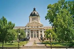
Hughes County[1] ist ein County im Bundesstaat South Dakota der Vereinigten Staaten. Der Verwaltungssitz (County Seat) ist Pierre, die Hauptstadt von South Dakota.
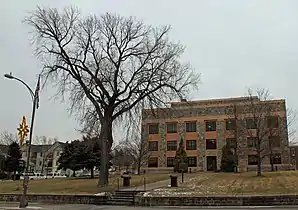 Hughes County Courthouse | |
| Verwaltung | |
|---|---|
| US-Bundesstaat: | South Dakota |
| Verwaltungssitz: | Pierre |
| Gründung: | 1880 |
| Demographie | |
| Einwohner: | 17.022 (2010) |
| Bevölkerungsdichte: | 8,87 Einwohner/km2 |
| Geographie | |
| Fläche gesamt: | 2073 km² |
| Wasserfläche: | 154 km² |
| Karte | |
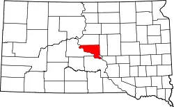 Karte von Hughes County innerhalb von South Dakota | |
Geographie
Der Bezirk hat eine Fläche von 2073 Quadratkilometern; davon sind 154 Quadratkilometer (7,42 %) Wasserflächen. Er wird in zwei Townships eingeteilt: Raber und Valley; sowie drei unorganisierte Territorien: West Hughes, North Hughes und Crow Creek.
Geschichte
Das County wurde am 8. Januar 1873 gegründet und die Verwaltungsorganisation am 26. November 1880 abgeschlossen. Es wurde nach Alexander Hughes benannt, der Anwalt und Präsident der gesetzgebenden Versammlung des Dakota-Territoriums war.[2]
Ein Ort im County hat den Status einer National Historic Landmark, die archäologische Fundstätte Arzberger Site.[3] 42 Bauwerke und Stätten des Countys sind im National Register of Historic Places (NRHP) eingetragen (Stand 2. August 2018).[4]
Bevölkerungsentwicklung
| Bevölkerungsentwicklung | |||
|---|---|---|---|
| Census | Einwohner | ± in % | |
| 1900 | 3684 | — | |
| 1910 | 6271 | 70,2 % | |
| 1920 | 5711 | −8,9 % | |
| 1930 | 7009 | 22,7 % | |
| 1940 | 6624 | −5,5 % | |
| 1950 | 8111 | 22,4 % | |
| 1960 | 12.725 | 56,9 % | |
| 1970 | 11.632 | −8,6 % | |
| 1980 | 14.220 | 22,2 % | |
| 1990 | 14.817 | 4,2 % | |
| 2000 | 16.481 | 11,2 % | |
| 2010 | 17.022 | 3,3 % | |
| 1900–1990[5]
2000[6] | |||
Städte und Gemeinden
Städte (cities)
- Blunt
- Pierre
Gemeinden (towns)
- Harrold
Gemeindefreie Dörfer
- Canning
Weblinks
Einzelnachweise
- Hughes County im Geographic Names Information System des United States Geological Survey. Abgerufen am 22. Februar 2011
- Charles Curry Aiken, Joseph Nathan Kane: The American Counties: Origins of County Names, Dates of Creation, Area, and Population Data, 1950–2010. 6. Auflage. Scarecrow Press, Lanham 2013, ISBN 978-0-8108-8762-6, S. 143.
- Listing of National Historic Landmarks by State: South Dakota. National Park Service, abgerufen am 2. August 2018.
- Suchmaske Datenbank im National Register Information System. National Park Service, abgerufen am 2. August 2018.
- Auszug aus Census.gov. Abgerufen am 28. Februar 2011
- Auszug aus factfinder.census.gov Abgerufen am 28. Februar 2011
Liste der Countys in South Dakota
Aurora |
Beadle |
Bennett |
Bon Homme |
Brookings |
Brown |
Brule |
Buffalo |
Butte |
Campbell |
Charles Mix |
Clark |
Clay |
Codington |
Corson |
Custer |
Davison |
Day |
Deuel |
Dewey |
Douglas |
Edmunds |
Fall River |
Faulk |
Grant |
Gregory |
Haakon |
Hamlin |
Hand |
Hanson |
Harding |
Hughes |
Hutchinson |
Hyde |
Jackson |
Jerauld |
Jones |
Kingsbury |
Lake |
Lawrence |
Lincoln |
Lyman |
Marshall |
McCook |
McPherson |
Meade |
Mellette |
Miner |
Minnehaha |
Moody |
Oglala Lakota |
Pennington |
Perkins |
Potter |
Roberts |
Sanborn |
Spink |
Stanley |
Sully |
Todd |
Tripp |
Turner |
Union |
Walworth |
Yankton |
Ziebach