Codington County
Codington County[1] ist ein County im Nordosten des US-Bundesstaates South Dakota, Vereinigte Staaten.
 Codington County Courthouse | |
| Verwaltung | |
|---|---|
| US-Bundesstaat: | South Dakota |
| Verwaltungssitz: | Watertown |
| Gründung: | 1877 |
| Demographie | |
| Einwohner: | 27.227 (2010) |
| Bevölkerungsdichte: | 15,29 Einwohner/km2 |
| Geographie | |
| Fläche gesamt: | 1857 km² |
| Wasserfläche: | 76 km² |
| Karte | |
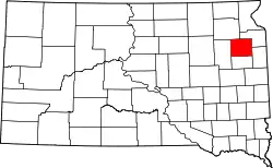 Karte von Codington County innerhalb von South Dakota | |
| Website: www.codington.org | |
Geographie
Der Bezirk hat eine Fläche von 1857 Quadratkilometern; davon sind 76 Quadratkilometer (4,10 Prozent) Wasserflächen. Er wird in 17 Townships eingeteilt: Dexter, Eden, Elmira, Fuller, Germantown, Graceland, Henry, Kampeska, Kranzburg, Lake, Leola, Pelican, Phipps, Rauville, Richland, Sheridan und Waverly.
Geschichte
Das County wurde am 15. Februar 1877 gegründet und die Verwaltung am 7. August 1878 abschließend organisiert. Benannt wurde es nach G.S. Codington, einem protestantischen Geistlichen und Abgeordneten in der gesetzgebenden Versammlung des Dakota-Territoriums.[2]

43 Bauwerke und Stätten des Countys sind im National Register of Historic Places (NRHP) eingetragen (Stand 30. Juli 2018).[3]
Bevölkerungsentwicklung
| Bevölkerungsentwicklung | |||
|---|---|---|---|
| Census | Einwohner | ± in % | |
| 1900 | 8770 | — | |
| 1910 | 14.092 | 60,7 % | |
| 1920 | 16.549 | 17,4 % | |
| 1930 | 17.457 | 5,5 % | |
| 1940 | 17.014 | −2,5 % | |
| 1950 | 18.944 | 11,3 % | |
| 1960 | 20.220 | 6,7 % | |
| 1970 | 19.140 | −5,3 % | |
| 1980 | 20.885 | 9,1 % | |
| 1990 | 22.698 | 8,7 % | |
| 2000 | 25.897 | 14,1 % | |
| 2010 | 27.227 | 5,1 % | |
| 1900–1990[4]
2010[5] | |||
Städte und Gemeinden
Städte (cities)
Gemeinden (towns)
- Florence
- Henry
- Kranzburg
- South Shore
- Wallace
Weblinks
Einzelnachweise
- Codington County im Geographic Names Information System des United States Geological Survey. Abgerufen am 22. Februar 2011
- Charles Curry Aiken, Joseph Nathan Kane: The American Counties: Origins of County Names, Dates of Creation, Area, and Population Data, 1950–2010. 6. Auflage. Scarecrow Press, Lanham 2013, ISBN 978-0-8108-8762-6, S. 65.
- Suchmaske Datenbank im National Register Information System. National Park Service, abgerufen am 30. Juli 2018.
- Auszug aus Census.gov. Abgerufen am 28. Februar 2011
- Auszug aus factfinder.census.gov. Abgerufen am 28. September 2018.
Liste der Countys in South Dakota
Aurora |
Beadle |
Bennett |
Bon Homme |
Brookings |
Brown |
Brule |
Buffalo |
Butte |
Campbell |
Charles Mix |
Clark |
Clay |
Codington |
Corson |
Custer |
Davison |
Day |
Deuel |
Dewey |
Douglas |
Edmunds |
Fall River |
Faulk |
Grant |
Gregory |
Haakon |
Hamlin |
Hand |
Hanson |
Harding |
Hughes |
Hutchinson |
Hyde |
Jackson |
Jerauld |
Jones |
Kingsbury |
Lake |
Lawrence |
Lincoln |
Lyman |
Marshall |
McCook |
McPherson |
Meade |
Mellette |
Miner |
Minnehaha |
Moody |
Oglala Lakota |
Pennington |
Perkins |
Potter |
Roberts |
Sanborn |
Spink |
Stanley |
Sully |
Todd |
Tripp |
Turner |
Union |
Walworth |
Yankton |
Ziebach