Sully County
Sully County[1] ist ein Bezirk im Bundesstaat South Dakota der Vereinigten Staaten. Der Sitz der Countyverwaltung (County Seat) ist in Onida.
 Sully County Courthouse, einer von vier Einträgen des Countys im NRHP | |
| Verwaltung | |
|---|---|
| US-Bundesstaat: | South Dakota |
| Verwaltungssitz: | Onida |
| Gründung: | 1909 |
| Demographie | |
| Einwohner: | 1373 (2010) |
| Bevölkerungsdichte: | 0,53 Einwohner/km2 |
| Geographie | |
| Fläche gesamt: | 2772 km² |
| Wasserfläche: | 164 km² |
| Karte | |
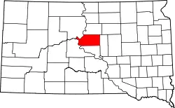 Karte von Sully County innerhalb von South Dakota | |
Geographie
Das County hat eine Fläche von 2.772 Quadratkilometern. Davon sind 2.608 km² Land und 164 km² (5,93 %) Wasserfläche. Er ist eingeteilt in zwei unorganisierte Territorien: West Sully und East Sully. Es grenzt im Uhrzeigersinn an die Countys: Potter County, Hyde County, Hughes County, Stanley County und Dewey County.
Geschichte
Das County wurde am 8. Januar 1873 gegründet und die Verwaltungsorganisation am 19. April 1883 abgeschlossen. Es wurde nach dem Offizier Alfred Sully benannt, der im Sezessionskrieg in der Unionsarmee diente.[2]
Vier Bauwerke und Stätten des Countys sind im National Register of Historic Places (NRHP) eingetragen (Stand 9. August 2018).[3]
Bevölkerungsentwicklung
| Bevölkerungsentwicklung | |||
|---|---|---|---|
| Census | Einwohner | ± in % | |
| 1900 | 1715 | — | |
| 1910 | 2462 | 43,6 % | |
| 1920 | 2831 | 15 % | |
| 1930 | 3852 | 36,1 % | |
| 1940 | 2668 | −30,7 % | |
| 1950 | 2713 | 1,7 % | |
| 1960 | 2607 | −3,9 % | |
| 1970 | 2362 | −9,4 % | |
| 1980 | 1990 | −15,7 % | |
| 1990 | 1589 | −20,2 % | |
| 2000 | 1556 | −2,1 % | |
| 2010 | 1373 | −11,8 % | |
| 1900–1990[4]
2000[5] | |||
Städte und Gemeinden
Städte (cities):
- Onida
Gemeinden (towns):
- Agar
Weblinks
Einzelnachweise
- Sully County im Geographic Names Information System des United States Geological Survey. Abgerufen am 22. Februar 2011
- Charles Curry Aiken, Joseph Nathan Kane: The American Counties: Origins of County Names, Dates of Creation, Area, and Population Data, 1950–2010. 6. Auflage. Scarecrow Press, Lanham 2013, ISBN 978-0-8108-8762-6, S. 293.
- Suchmaske Datenbank im National Register Information System. National Park Service, abgerufen am 9. August 2018.
- Auszug aus Census.gov. Abgerufen am 28. Februar 2011
- Auszug aus factfinder.census.gov Abgerufen am 28. Februar 2011
Liste der Countys in South Dakota
Aurora |
Beadle |
Bennett |
Bon Homme |
Brookings |
Brown |
Brule |
Buffalo |
Butte |
Campbell |
Charles Mix |
Clark |
Clay |
Codington |
Corson |
Custer |
Davison |
Day |
Deuel |
Dewey |
Douglas |
Edmunds |
Fall River |
Faulk |
Grant |
Gregory |
Haakon |
Hamlin |
Hand |
Hanson |
Harding |
Hughes |
Hutchinson |
Hyde |
Jackson |
Jerauld |
Jones |
Kingsbury |
Lake |
Lawrence |
Lincoln |
Lyman |
Marshall |
McCook |
McPherson |
Meade |
Mellette |
Miner |
Minnehaha |
Moody |
Oglala Lakota |
Pennington |
Perkins |
Potter |
Roberts |
Sanborn |
Spink |
Stanley |
Sully |
Todd |
Tripp |
Turner |
Union |
Walworth |
Yankton |
Ziebach