Perkins County (South Dakota)
Perkins County[1] ist ein County im Bundesstaat South Dakota der Vereinigten Staaten. Der Sitz der Countyverwaltung (County Seat) ist in Bison.
| Verwaltung | |
|---|---|
| US-Bundesstaat: | South Dakota |
| Verwaltungssitz: | Bison |
| Gründung: | 1909 |
| Demographie | |
| Einwohner: | 2982 (2010) |
| Bevölkerungsdichte: | 0,4 Einwohner/km2 |
| Geographie | |
| Fläche gesamt: | 7487 km² |
| Wasserfläche: | 49 km² |
| Karte | |
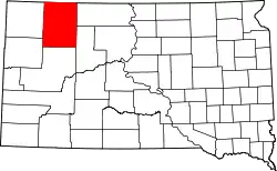 Karte von Perkins County innerhalb von South Dakota | |
Geographie
Das County hat eine Fläche von 7487 Quadratkilometern, was etwa halb so groß ist wie Schleswig-Holstein. Davon sind 49 Quadratkilometer (0,66 Prozent) Wasserfläche. Das County grenzt im Uhrzeigersinn an die Countys: Adams County (North Dakota), Corson County, Ziebach County, Meade County, Butte County und Harding.
Geschichte
Das County wurde 1909 gebildet.[2]
18 Bauwerke und Stätten des Countys sind im National Register of Historic Places (NRHP) eingetragen (Stand 8. August 2018).[3]
Bevölkerungsentwicklung
| Bevölkerungsentwicklung | |||
|---|---|---|---|
| Census | Einwohner | ± in % | |
| 1910 | 11.348 | — | |
| 1920 | 7993 | −29,6 % | |
| 1930 | 8717 | 9,1 % | |
| 1940 | 6585 | −24,5 % | |
| 1950 | 6776 | 2,9 % | |
| 1960 | 5977 | −11,8 % | |
| 1970 | 4769 | −20,2 % | |
| 1980 | 4700 | −1,4 % | |
| 1990 | 3932 | −16,3 % | |
| 2000 | 3363 | −14,5 % | |
| 2010 | 2982 | −11,3 % | |
| 1900–1990[4]
2000[5] | |||
Städte und Gemeinden
Städte (cities)
- Lemmon
Gemeinden (towns)
- Bison
Townships
Das County ist in 49 Townships eingeteilt: Ada, Anderson, Antelope, Barrett, Beck, Bision, Brushy, Burdick, Cash, Castle Butte, Chance, Chaudoin, Clark, De Witt, Duell, Englewood, Flat Creek, Foster, Fredlung, Glendo, Grand River, Hall, Highland, Horse Creek, Liberty, Lincoln, Lodgepole, Lone tree, Maltby, Marshfield, Martin, Meadow, Moreau, Plateau, Rainbow, Rockford, Scotch Cap, Sidney, Strool, Trail, Vail, Vickers, Viking, Vrooman, Wells, White Butte, White Hill, Wilson und Wyandotte; sowie acht unorganisierte Territorien: Duck Creek, East Perkins, Independence, Pleasant Valley, South Perkins, Southwest Perkins, West Central Perkins und West Perkins.
Weblinks
Einzelnachweise
- Perkins County im Geographic Names Information System des United States Geological Survey. Abgerufen am 22. Februar 2011
- About us auf Website Perkins County.
- Suchmaske Datenbank im National Register Information System. National Park Service, abgerufen am 8. August 2018.
- Auszug aus Census.gov. Abgerufen am 28. Februar 2011
- Auszug aus factfinder.census.gov Abgerufen am 28. Februar 2011
Liste der Countys in South Dakota
Aurora |
Beadle |
Bennett |
Bon Homme |
Brookings |
Brown |
Brule |
Buffalo |
Butte |
Campbell |
Charles Mix |
Clark |
Clay |
Codington |
Corson |
Custer |
Davison |
Day |
Deuel |
Dewey |
Douglas |
Edmunds |
Fall River |
Faulk |
Grant |
Gregory |
Haakon |
Hamlin |
Hand |
Hanson |
Harding |
Hughes |
Hutchinson |
Hyde |
Jackson |
Jerauld |
Jones |
Kingsbury |
Lake |
Lawrence |
Lincoln |
Lyman |
Marshall |
McCook |
McPherson |
Meade |
Mellette |
Miner |
Minnehaha |
Moody |
Oglala Lakota |
Pennington |
Perkins |
Potter |
Roberts |
Sanborn |
Spink |
Stanley |
Sully |
Todd |
Tripp |
Turner |
Union |
Walworth |
Yankton |
Ziebach