Faulk County
Faulk County[1] ist ein County im Bundesstaat South Dakota der Vereinigten Staaten. Er hat 2640 Einwohner. Der Verwaltungssitz (County Seat) ist Faulkton.
 Faulk County Courthouse | |
| Verwaltung | |
|---|---|
| US-Bundesstaat: | South Dakota |
| Verwaltungssitz: | Faulkton |
| Gründung: | 1873 |
| Demographie | |
| Einwohner: | 2364 (2010) |
| Bevölkerungsdichte: | 0,91 Einwohner/km2 |
| Geographie | |
| Fläche gesamt: | 2605 km² |
| Wasserfläche: | 14 km² |
| Karte | |
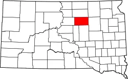 Karte von Faulk County innerhalb von South Dakota | |
Geographie
Der Bezirk hat eine Fläche von 2605 Quadratkilometern; davon sind 14 Quadratkilometer (0,55 Prozent) Wasserflächen. Er ist in 23 Townships eingeteilt: Arcade, Bryant, Centerville, Clark, Devoe, Ellisville, Emerson, Enterprise, Fairview, Freedom, Hillsdale, Irving, Lafoon, Myron, O'Neil, Orient, Pioneer, Saratoga, Sherman, Tamworth, Union, Wesley und Zell; sowie drei unorganisierte Territorien: Pulaski und Southwest Faulk.
Geschichte
Das County wurde am 8. Januar 1873 gegründet und die Verwaltungsorganisation am 5. November 1883 abgeschlossen. Es wurde nach dem Politiker Andrew Jackson Faulk benannt, der unter anderem Gouverneur des Dakota-Territoriums war.[2]
Neun Bauwerke und Stätten des Countys sind im National Register of Historic Places (NRHP) eingetragen (Stand 31. Juli 2018).[3]
Bevölkerungsentwicklung
| Bevölkerungsentwicklung | |||
|---|---|---|---|
| Census | Einwohner | ± in % | |
| 1900 | 3547 | — | |
| 1910 | 6716 | 89,3 % | |
| 1920 | 6442 | −4,1 % | |
| 1930 | 6895 | 7 % | |
| 1940 | 5168 | −25 % | |
| 1950 | 4752 | −8 % | |
| 1960 | 4397 | −7,5 % | |
| 1970 | 3893 | −11,5 % | |
| 1980 | 3327 | −14,5 % | |
| 1990 | 2744 | −17,5 % | |
| 2000 | 2640 | −3,8 % | |
| 2010 | 2364 | −10,5 % | |
| 1900–1990[4]
2000[5] | |||
Städte und Gemeinden
Städte (cities)
- Faulkton
Gemeinden (towns)
- Chelsea
- Cresbard
- Onako
- Orient
- Rockham
- Seneca
- Wecota
Weblinks
Einzelnachweise
- Faulk County im Geographic Names Information System des United States Geological Survey. Abgerufen am 22. Februar 2011
- Charles Curry Aiken, Joseph Nathan Kane: The American Counties: Origins of County Names, Dates of Creation, Area, and Population Data, 1950–2010. 6. Auflage. Scarecrow Press, Lanham 2013, ISBN 978-0-8108-8762-6, S. 99.
- Suchmaske Datenbank im National Register Information System. National Park Service, abgerufen am 31. Juli 2018.
- Auszug aus Census.gov. Abgerufen am 28. Februar 2011
- Auszug aus factfinder.census.gov Abgerufen am 28. Februar 2011
Liste der Countys in South Dakota
Aurora |
Beadle |
Bennett |
Bon Homme |
Brookings |
Brown |
Brule |
Buffalo |
Butte |
Campbell |
Charles Mix |
Clark |
Clay |
Codington |
Corson |
Custer |
Davison |
Day |
Deuel |
Dewey |
Douglas |
Edmunds |
Fall River |
Faulk |
Grant |
Gregory |
Haakon |
Hamlin |
Hand |
Hanson |
Harding |
Hughes |
Hutchinson |
Hyde |
Jackson |
Jerauld |
Jones |
Kingsbury |
Lake |
Lawrence |
Lincoln |
Lyman |
Marshall |
McCook |
McPherson |
Meade |
Mellette |
Miner |
Minnehaha |
Moody |
Oglala Lakota |
Pennington |
Perkins |
Potter |
Roberts |
Sanborn |
Spink |
Stanley |
Sully |
Todd |
Tripp |
Turner |
Union |
Walworth |
Yankton |
Ziebach