Spink County
Spink County[1] ist ein County im Bundesstaat South Dakota der Vereinigten Staaten.
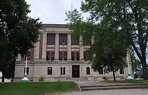 Spink County Courthouse, einer von 25 Einträgen des Countys im NRHP | |
| Verwaltung | |
|---|---|
| US-Bundesstaat: | South Dakota |
| Verwaltungssitz: | Redfield |
| Gründung: | 1873 |
| Demographie | |
| Einwohner: | 6415 (2010) |
| Bevölkerungsdichte: | 1,65 Einwohner/km2 |
| Geographie | |
| Fläche gesamt: | 3911 km² |
| Wasserfläche: | 16 km² |
| Karte | |
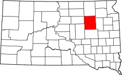 Karte von Spink County innerhalb von South Dakota | |
| Website: www.co.pennington.sd.us | |
Geographie
Das County hatte nach dem United States Census Bureau eine Fläche von 3911 Quadratkilometern; davon sind 16 Quadratkilometer (0,41 Prozent) Wasserflächen. Das County grenzt im Uhrzeigersinn an folgende Countys: Brown County (Norden), Day County (Nordosten), Clark County (Osten), Beadle County (Süd), Hand County (Südwest) und Faulk County (Westen).
Geschichte
Das County wurde am 8. Januar 1873 gegründet und die Verwaltungsorganisation am 1. August 1879 abgeschlossen. Es wurde nach dem Politiker Solomon L. Spink benannt, der Delegierter für das Dakota-Territorium im Repräsentantenhaus der Vereinigten Staaten war.[2]
25 Bauwerke und Stätten des Countys sind im National Register of Historic Places (NRHP) eingetragen (Stand 9. August 2018).[3]
Bevölkerungsentwicklung
| Bevölkerungsentwicklung | |||
|---|---|---|---|
| Census | Einwohner | ± in % | |
| 1900 | 9487 | — | |
| 1910 | 15.981 | 68,5 % | |
| 1920 | 15.768 | −1,3 % | |
| 1930 | 15.304 | −2,9 % | |
| 1940 | 12.527 | −18,1 % | |
| 1950 | 12.204 | −2,6 % | |
| 1960 | 11.706 | −4,1 % | |
| 1970 | 10.595 | −9,5 % | |
| 1980 | 9201 | −13,2 % | |
| 1990 | 7981 | −13,3 % | |
| 2000 | 7454 | −6,6 % | |
| 2010 | 6415 | −13,9 % | |
| 1900–1990[4]
2000[5] | |||
Städte und Gemeinden
Städte (cities)
- Ashton
- Conde
- Doland
- Frankfort
- Mellette
- Redfield
Gemeinden (towns)
- Brentford
- Northville
- Tulare
- Turton
Weblinks
Einzelnachweise
- Spink County im Geographic Names Information System des United States Geological Survey. Abgerufen am 22. Februar 2011
- Charles Curry Aiken, Joseph Nathan Kane: The American Counties: Origins of County Names, Dates of Creation, Area, and Population Data, 1950–2010. 6. Auflage. Scarecrow Press, Lanham 2013, ISBN 978-0-8108-8762-6, S. 287.
- Suchmaske Datenbank im National Register Information System. National Park Service, abgerufen am 9. August 2018.
- Auszug aus Census.gov. Abgerufen am 28. Februar 2011
- Auszug aus factfinder.census.gov Abgerufen am 28. Februar 2011
Liste der Countys in South Dakota
Aurora |
Beadle |
Bennett |
Bon Homme |
Brookings |
Brown |
Brule |
Buffalo |
Butte |
Campbell |
Charles Mix |
Clark |
Clay |
Codington |
Corson |
Custer |
Davison |
Day |
Deuel |
Dewey |
Douglas |
Edmunds |
Fall River |
Faulk |
Grant |
Gregory |
Haakon |
Hamlin |
Hand |
Hanson |
Harding |
Hughes |
Hutchinson |
Hyde |
Jackson |
Jerauld |
Jones |
Kingsbury |
Lake |
Lawrence |
Lincoln |
Lyman |
Marshall |
McCook |
McPherson |
Meade |
Mellette |
Miner |
Minnehaha |
Moody |
Oglala Lakota |
Pennington |
Perkins |
Potter |
Roberts |
Sanborn |
Spink |
Stanley |
Sully |
Todd |
Tripp |
Turner |
Union |
Walworth |
Yankton |
Ziebach