McCook County
McCook County[1] ist ein County im Bundesstaat South Dakota der Vereinigten Staaten. Er wurde nach dem früheren Gouverneur von South Dakota Edwin Stanton McCook benannt. Der Sitz der Countyverwaltung (County Seat) ist in Salem.
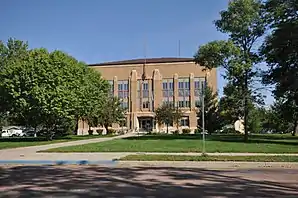 McCook County Courthouse | |
| Verwaltung | |
|---|---|
| US-Bundesstaat: | South Dakota |
| Verwaltungssitz: | Salem |
| Gründung: | 1973 |
| Demographie | |
| Einwohner: | 5618 (2010) |
| Bevölkerungsdichte: | 3,78 Einwohner/km2 |
| Geographie | |
| Fläche gesamt: | 1495 km² |
| Wasserfläche: | 7 km² |
| Karte | |
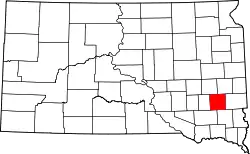 Karte von McCook County innerhalb von South Dakota | |
Geographie
Das County hat eine Fläche von 1.495 Quadratkilometern; davon sind 7 Quadratkilometer (0,46 Prozent) Wasserflächen. Er ist in 17 Townships eingeteilt: Benton, Bridgewater, Brookfield, Canistota, Emery, Grant, Greenland, Jefferson, Pearl, Montrose, Union, Ramsey, Richland, Salem, Spring Valley und Sun Prairie.
Geschichte
Das County wurde am 8. Januar 1873 gegründet und die Verwaltungsorganisation am 15. Juni 1878 abgeschlossen. Es wurde nach Edwin Stanton McCook (1837–1873) benannt, einem Offizier in der Unionsarmee und Sekretär des Dakota-Territoriums.[2]

Neun Bauwerke und Stätten des Countys sind im National Register of Historic Places (NRHP) eingetragen (Stand 6. August 2018).[3]
Bevölkerungsentwicklung
| Bevölkerungsentwicklung | |||
|---|---|---|---|
| Census | Einwohner | ± in % | |
| 1900 | 8689 | — | |
| 1910 | 9589 | 10,4 % | |
| 1920 | 9990 | 4,2 % | |
| 1930 | 10.316 | 3,3 % | |
| 1940 | 9793 | −5,1 % | |
| 1950 | 8828 | −9,9 % | |
| 1960 | 8268 | −6,3 % | |
| 1970 | 7246 | −12,4 % | |
| 1980 | 6444 | −11,1 % | |
| 1990 | 5688 | −11,7 % | |
| 2000 | 5832 | 2,5 % | |
| 2010 | 5618 | −3,7 % | |
| 1900–1990[4]
2000[5] | |||
Städte und Gemeinden
Städte (cities)
- Bridgewater
- Canistota
- Montrose
- Salem
- Spencer
geplante Siedlung
Weblinks
Einzelnachweise
- McCook County im Geographic Names Information System des United States Geological Survey. Abgerufen am 22. Februar 2011
- Charles Curry Aiken, Joseph Nathan Kane: The American Counties: Origins of County Names, Dates of Creation, Area, and Population Data, 1950–2010. 6. Auflage. Scarecrow Press, Lanham 2013, ISBN 978-0-8108-8762-6, S. 198.
- Suchmaske Datenbank im National Register Information System. National Park Service, abgerufen am 6. August 2018.
- Auszug aus Census.gov. Abgerufen am 28. Februar 2011
- Auszug aus factfinder.census.gov Abgerufen am 28. Februar 2011
Liste der Countys in South Dakota
Aurora |
Beadle |
Bennett |
Bon Homme |
Brookings |
Brown |
Brule |
Buffalo |
Butte |
Campbell |
Charles Mix |
Clark |
Clay |
Codington |
Corson |
Custer |
Davison |
Day |
Deuel |
Dewey |
Douglas |
Edmunds |
Fall River |
Faulk |
Grant |
Gregory |
Haakon |
Hamlin |
Hand |
Hanson |
Harding |
Hughes |
Hutchinson |
Hyde |
Jackson |
Jerauld |
Jones |
Kingsbury |
Lake |
Lawrence |
Lincoln |
Lyman |
Marshall |
McCook |
McPherson |
Meade |
Mellette |
Miner |
Minnehaha |
Moody |
Oglala Lakota |
Pennington |
Perkins |
Potter |
Roberts |
Sanborn |
Spink |
Stanley |
Sully |
Todd |
Tripp |
Turner |
Union |
Walworth |
Yankton |
Ziebach