Marshall County (South Dakota)
Marshall County[3] ist ein County im Bundesstaat South Dakota der Vereinigten Staaten. Der Sitz der Countyverwaltung (County Seat) ist in Britton.
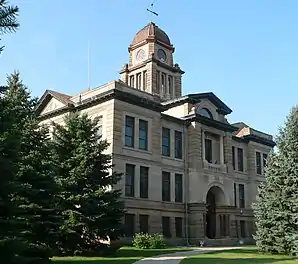 Das Marshall County Courthouse in Britton, seit 2006 im NRHP gelistet[2] | |
| Verwaltung | |
|---|---|
| US-Bundesstaat: | South Dakota |
| Verwaltungssitz: | Britton |
| Gründung: | 1885 |
| Demographie | |
| Einwohner: | 4656 (2010) |
| Bevölkerungsdichte: | 2,15 Einwohner/km2 |
| Geographie | |
| Fläche gesamt: | 2294 km² |
| Wasserfläche: | 124 km² |
| Karte | |
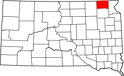 Karte von Marshall County innerhalb von South Dakota | |
Geographie
Das County hat eine Fläche von 2294 Quadratkilometern; davon sind 124 Quadratkilometer (5,41 Prozent) Wasserflächen. Er wird in 25 Townships eingeteilt: Buffalo, Dayton, Dumarce, Eden, Fort, Hamilton, Hickman, La Belle, Lake, Lowell, McKinley, Miller, Newark, Newport, Nordland, Pleasant Valley, Red Iron Lake, Sisseton, Stena, Veblen, Victor, Waverly, Weston, White und Wismer.
Geschichte
Das County wurde am 10. März 1885 gegründet und nach Marshall Vincent benannt, dem Oberbeamten des Day County, aus dem das Marshall County gebildet wurde.[4]
Sechs Bauwerke und Stätten des Countys sind im National Register of Historic Places (NRHP) eingetragen (Stand 6. August 2018).[5]
Bevölkerungsentwicklung
| Bevölkerungsentwicklung | |||
|---|---|---|---|
| Census | Einwohner | ± in % | |
| 1900 | 5942 | — | |
| 1910 | 8021 | 35 % | |
| 1920 | 9596 | 19,6 % | |
| 1930 | 9540 | −0,6 % | |
| 1940 | 8880 | −6,9 % | |
| 1950 | 7835 | −11,8 % | |
| 1960 | 6663 | −15 % | |
| 1970 | 5965 | −10,5 % | |
| 1980 | 5404 | −9,4 % | |
| 1990 | 4844 | −10,4 % | |
| 2000 | 4576 | −5,5 % | |
| 2010 | 4656 | 1,7 % | |
| 1900–1990[6]
2000[7] | |||
Städte und Gemeinden
Städte (cities)
- Britton
- Veblen
Gemeinden (towns)
- Eden
- Lake City
- Langford
Weblinks
Einzelnachweise
- Auszug aus dem National Register of Historic Places - Nr. 06000047 Abgerufen am 10. Januar 2019
- Auszug aus dem National Register of Historic Places - Nr. 06000047 Abgerufen am 10. Januar 2019
- Marshall County im Geographic Names Information System des United States Geological Survey. Abgerufen am 22. Februar 2011
- Charles Curry Aiken, Joseph Nathan Kane: The American Counties: Origins of County Names, Dates of Creation, Area, and Population Data, 1950–2010. 6. Auflage. Scarecrow Press, Lanham 2013, ISBN 978-0-8108-8762-6, S. 195.
- Suchmaske Datenbank im National Register Information System. National Park Service, abgerufen am 6. August 2018.
- Auszug aus Census.gov. Abgerufen am 28. Februar 2011
- Auszug aus factfinder.census.gov Abgerufen am 28. Februar 2011
Liste der Countys in South Dakota
Aurora |
Beadle |
Bennett |
Bon Homme |
Brookings |
Brown |
Brule |
Buffalo |
Butte |
Campbell |
Charles Mix |
Clark |
Clay |
Codington |
Corson |
Custer |
Davison |
Day |
Deuel |
Dewey |
Douglas |
Edmunds |
Fall River |
Faulk |
Grant |
Gregory |
Haakon |
Hamlin |
Hand |
Hanson |
Harding |
Hughes |
Hutchinson |
Hyde |
Jackson |
Jerauld |
Jones |
Kingsbury |
Lake |
Lawrence |
Lincoln |
Lyman |
Marshall |
McCook |
McPherson |
Meade |
Mellette |
Miner |
Minnehaha |
Moody |
Oglala Lakota |
Pennington |
Perkins |
Potter |
Roberts |
Sanborn |
Spink |
Stanley |
Sully |
Todd |
Tripp |
Turner |
Union |
Walworth |
Yankton |
Ziebach