Hutchinson County (South Dakota)
Hutchison County[1] ist ein County im Bundesstaat South Dakota der Vereinigten Staaten.
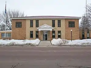 Hutchinson County Courthouse | |
| Verwaltung | |
|---|---|
| US-Bundesstaat: | South Dakota |
| Verwaltungssitz: | Olivet |
| Gründung: | |
| Demographie | |
| Einwohner: | 7343 (2010) |
| Bevölkerungsdichte: | 3,49 Einwohner/km2 |
| Geographie | |
| Fläche gesamt: | 2109 km² |
| Wasserfläche: | 4 km² |
| Karte | |
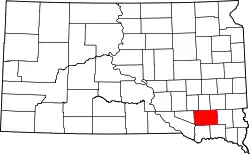 Karte von Hutchinson County innerhalb von South Dakota | |
Geographie
Das County hat eine Fläche von 2109 Quadratkilometern; davon sind 4 Quadratkilometer (0,19 Prozent) Wasserflächen. Er wird in 23 Townships eingeteilt: Capital, Clayton, Cross Plains, Fair, Foster, German, Grandview, Hassel, Kaylor, Kuim, Liberty, Mittown, Molan, Oak Hollow, Pleasant, Sharon, Silver Lake, Starr, Susquehanna, Sweet, Valley, Wittenberg und Wolf Creek.
Geschichte
Das County wurde am 8. Mai 1862 gegründet und die Verwaltungsorganisation am 13. Januar 1871 abgeschlossen. Es wurde nach John S. Hutchinson benannt (1829–1889), der Sekretär und geschäftsführender Gouverneur des Dakota-Territoriums war.[2]
29 Bauwerke und Stätten des Countys sind im National Register of Historic Places (NRHP) eingetragen (Stand 2. August 2018).[3]
Bevölkerungsentwicklung
| Bevölkerungsentwicklung | |||
|---|---|---|---|
| Census | Einwohner | ± in % | |
| 1900 | 11.897 | — | |
| 1910 | 12.319 | 3,5 % | |
| 1920 | 13.475 | 9,4 % | |
| 1930 | 13.904 | 3,2 % | |
| 1940 | 12.668 | −8,9 % | |
| 1950 | 11.423 | −9,8 % | |
| 1960 | 11.085 | −3 % | |
| 1970 | 10.379 | −6,4 % | |
| 1980 | 9350 | −9,9 % | |
| 1990 | 8262 | −11,6 % | |
| 2000 | 8075 | −2,3 % | |
| 2010 | 7343 | −9,1 % | |
| 1900–1990[4]
2000[5] | |||
Städte und Gemeinden
Städte (cities)
- Freeman
- Menno
- Parkston
- Tripp
Gemeinden (towns)
- Dimock
- Olivet
- Kaylor
- Milltown
Weblinks
Einzelnachweise
- Hutchinson County im Geographic Names Information System des United States Geological Survey. Abgerufen am 22. Februar 2011
- Charles Curry Aiken, Joseph Nathan Kane: The American Counties: Origins of County Names, Dates of Creation, Area, and Population Data, 1950–2010. 6. Auflage. Scarecrow Press, Lanham 2013, ISBN 978-0-8108-8762-6, S. 144.
- Suchmaske Datenbank im National Register Information System. National Park Service, abgerufen am 2. August 2018.
- Auszug aus Census.gov. Abgerufen am 28. Februar 2011
- Auszug aus factfinder.census.gov Abgerufen am 28. Februar 2011
Liste der Countys in South Dakota
Aurora |
Beadle |
Bennett |
Bon Homme |
Brookings |
Brown |
Brule |
Buffalo |
Butte |
Campbell |
Charles Mix |
Clark |
Clay |
Codington |
Corson |
Custer |
Davison |
Day |
Deuel |
Dewey |
Douglas |
Edmunds |
Fall River |
Faulk |
Grant |
Gregory |
Haakon |
Hamlin |
Hand |
Hanson |
Harding |
Hughes |
Hutchinson |
Hyde |
Jackson |
Jerauld |
Jones |
Kingsbury |
Lake |
Lawrence |
Lincoln |
Lyman |
Marshall |
McCook |
McPherson |
Meade |
Mellette |
Miner |
Minnehaha |
Moody |
Oglala Lakota |
Pennington |
Perkins |
Potter |
Roberts |
Sanborn |
Spink |
Stanley |
Sully |
Todd |
Tripp |
Turner |
Union |
Walworth |
Yankton |
Ziebach