Bon Homme County
Bon Homme County[1] ist ein County im Bundesstaat South Dakota der Vereinigten Staaten. Es liegt im Süden des Bundesstaates an der Grenze zu Nebraska. Im County leben 7260 Einwohner. Der Verwaltungssitz (County Seat) ist Tyndall.
 Bon Homme County Courthouse | |
| Verwaltung | |
|---|---|
| US-Bundesstaat: | South Dakota |
| Verwaltungssitz: | Tyndall |
| Gründung: | |
| Demographie | |
| Einwohner: | 7070 (2010) |
| Bevölkerungsdichte: | 4,85 Einwohner/km2 |
| Geographie | |
| Fläche gesamt: | 1506 km² |
| Wasserfläche: | 47 km² |
| Karte | |
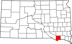 Karte von Bon Homme County innerhalb von South Dakota | |
Geographie
Das County liegt im Südosten von South Dakota, grenzt im Süden an Nebraska und hat eine Fläche von 1.506 Quadratkilometern; davon sind 47 Quadratkilometer (3,09 Prozent) Wasserflächen. Bon Homme County grenzt im Uhrzeigersinn an folgende andere Countys: Hutchinson County, Yankton County, Knox County und Charles Mix County.
Geschichte
Das County wurde am 8. April 1862 gebildet. Es ist nach einer Insel im Missouri River benannt. Der Name geht auf die französische Phrase bon homme Jaqques (deutsch: „Guter Mann Jacques“) zurück, eine ehemals höhnische Bezeichnung für Bauern, die später mit Stolz getragen wurde.[2]
_from_WNW_1.JPG.webp)
39 Bauwerke und Stätten des Countys sind im National Register of Historic Places (NRHP) eingetragen (Stand 30. Juli 2018).[3]
Bevölkerungsentwicklung
| Bevölkerungsentwicklung | |||
|---|---|---|---|
| Census | Einwohner | ± in % | |
| 1900 | 10.379 | — | |
| 1910 | 11.061 | 6,6 % | |
| 1920 | 11.940 | 7,9 % | |
| 1930 | 11.737 | −1,7 % | |
| 1940 | 10.241 | −12,7 % | |
| 1950 | 9440 | −7,8 % | |
| 1960 | 9229 | −2,2 % | |
| 1970 | 8577 | −7,1 % | |
| 1980 | 8059 | −6 % | |
| 1990 | 7089 | −12 % | |
| 2000 | 7260 | 2,4 % | |
| 2010 | 7070 | −2,6 % | |
| 1900–1990[4]
2000[5] | |||
Städte und Dörfer
- Avon
- Scotland
- Springfield
- Tabor
- Tyndall
Weblinks
Einzelnachweise
- Bon Homme County im Geographic Names Information System des United States Geological Survey. Abgerufen am 22. Februar 2011
- Charles Curry Aiken, Joseph Nathan Kane: The American Counties: Origins of County Names, Dates of Creation, Area, and Population Data, 1950–2010. 6. Auflage. Scarecrow Press, Lanham 2013, ISBN 978-0-8108-8762-6, S. 26.
- Suchmaske Datenbank im National Register Information System. National Park Service, abgerufen am 30. Juli 2018.
- Auszug aus Census.gov. Abgerufen am 28. Februar 2011
- Auszug aus factfinder.census.gov Abgerufen am 28. Februar 2011
Liste der Countys in South Dakota
Aurora |
Beadle |
Bennett |
Bon Homme |
Brookings |
Brown |
Brule |
Buffalo |
Butte |
Campbell |
Charles Mix |
Clark |
Clay |
Codington |
Corson |
Custer |
Davison |
Day |
Deuel |
Dewey |
Douglas |
Edmunds |
Fall River |
Faulk |
Grant |
Gregory |
Haakon |
Hamlin |
Hand |
Hanson |
Harding |
Hughes |
Hutchinson |
Hyde |
Jackson |
Jerauld |
Jones |
Kingsbury |
Lake |
Lawrence |
Lincoln |
Lyman |
Marshall |
McCook |
McPherson |
Meade |
Mellette |
Miner |
Minnehaha |
Moody |
Oglala Lakota |
Pennington |
Perkins |
Potter |
Roberts |
Sanborn |
Spink |
Stanley |
Sully |
Todd |
Tripp |
Turner |
Union |
Walworth |
Yankton |
Ziebach