Charles Mix County
Charles Mix County[1] ist ein Bezirk im Süden des US-Bundesstaates South Dakota an der Grenze zu Nebraska. Im County leben 9350 Einwohner. Der Verwaltungssitz (County Seat) ist Lake Andes.
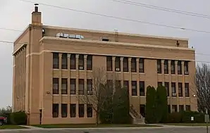 Charles Mix County Courthouse | |
| Verwaltung | |
|---|---|
| US-Bundesstaat: | South Dakota |
| Verwaltungssitz: | Lake Andes |
| Gründung: | 1862 |
| Demographie | |
| Einwohner: | 9129 (2010) |
| Bevölkerungsdichte: | 3,21 Einwohner/km2 |
| Geographie | |
| Fläche gesamt: | 2979 km² |
| Wasserfläche: | 136 km² |
| Karte | |
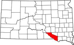 Karte von Charles Mix County innerhalb von South Dakota | |
Geographie
Das County hat eine Fläche von 2979 Quadratkilometern; davon sind 136 Quadratkilometer (4,57 Prozent) Wasserflächen. Es grenzt im Uhrzeigersinn an folgende andere Countys: Brule County, Aurora County, Douglas County, Hutchinson County, Bon Homme County, Knox County, Boyd County und Gregory County.
Geschichte
Das County wurde am 8. Mai 1862 gegründet und zwei Jahre später wieder aufgelöst. Im Jahr 1879 wurde das County erneut gebildet. Es wurde nach dem Indianeragenten und Offizier Charles H. Mix (1833–1909) benannt.[2]
_from_NE_1.JPG.webp)
13 Bauwerke und Stätten des Countys sind im National Register of Historic Places (NRHP) eingetragen (Stand 30. Juli 2018).[3]
Bevölkerungsentwicklung
| Bevölkerungsentwicklung | |||
|---|---|---|---|
| Census | Einwohner | ± in % | |
| 1900 | 8498 | — | |
| 1910 | 14.899 | 75,3 % | |
| 1920 | 16.256 | 9,1 % | |
| 1930 | 16.703 | 2,7 % | |
| 1940 | 13.449 | −19,5 % | |
| 1950 | 15.558 | 15,7 % | |
| 1960 | 11.785 | −24,3 % | |
| 1970 | 9994 | −15,2 % | |
| 1980 | 9680 | −3,1 % | |
| 1990 | 9131 | −5,7 % | |
| 2000 | 9350 | 2,4 % | |
| 2010 | 9129 | −2,4 % | |
| 1900–1990[4]
2000[5] | |||
Städte
Städte (cities)
- Geddes
- Lake Andes
- Platte
- Wagner
Gemeinden (towns)
- Dante
- Pickstown
- Ravinia
- Marty
Townships
Das County ist in 24 Townships eingeteilt: Bryan, Carroll, Choteau Creek, Darlington, Forbes, Goose Lake, Hamilton, Highland, Howard, Jackson, Kennedy, La Roche, Lake George, Lawrence, Lone Tree, Moore, Platte, Plain Center, Rhoda, Roe, Rouse, Signal, Waheheh und White Swan; sowie ein unorganisiertes Territorium: Castalia.
Weblinks
Einzelnachweise
- Charles Mix County im Geographic Names Information System des United States Geological Survey. Abgerufen am 22. Februar 2011
- Charles Curry Aiken, Joseph Nathan Kane: The American Counties: Origins of County Names, Dates of Creation, Area, and Population Data, 1950–2010. 6. Auflage. Scarecrow Press, Lanham 2013, ISBN 978-0-8108-8762-6, S. 50.
- Suchmaske Datenbank im National Register Information System. National Park Service, abgerufen am 30. Juli 2018.
- Auszug aus Census.gov. Abgerufen am 28. Februar 2011
- Auszug aus factfinder.census.gov Abgerufen am 28. Februar 2011
Liste der Countys in South Dakota
Aurora |
Beadle |
Bennett |
Bon Homme |
Brookings |
Brown |
Brule |
Buffalo |
Butte |
Campbell |
Charles Mix |
Clark |
Clay |
Codington |
Corson |
Custer |
Davison |
Day |
Deuel |
Dewey |
Douglas |
Edmunds |
Fall River |
Faulk |
Grant |
Gregory |
Haakon |
Hamlin |
Hand |
Hanson |
Harding |
Hughes |
Hutchinson |
Hyde |
Jackson |
Jerauld |
Jones |
Kingsbury |
Lake |
Lawrence |
Lincoln |
Lyman |
Marshall |
McCook |
McPherson |
Meade |
Mellette |
Miner |
Minnehaha |
Moody |
Oglala Lakota |
Pennington |
Perkins |
Potter |
Roberts |
Sanborn |
Spink |
Stanley |
Sully |
Todd |
Tripp |
Turner |
Union |
Walworth |
Yankton |
Ziebach