Aurora County
Aurora County [1] ist ein County im Bundesstaat South Dakota der Vereinigten Staaten. 3.058 Einwohner lebten hier im Jahre 2000. Der Verwaltungssitz (County Seat) ist Plankinton.
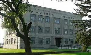 Aurora County Courthouse | |
| Verwaltung | |
|---|---|
| US-Bundesstaat: | South Dakota |
| Verwaltungssitz: | Plankinton |
| Gründung: | 1879 |
| Demographie | |
| Einwohner: | 2710 (2010) |
| Bevölkerungsdichte: | 1,48 Einwohner/km2 |
| Geographie | |
| Fläche gesamt: | 1845 km² |
| Wasserfläche: | 11 km² |
| Karte | |
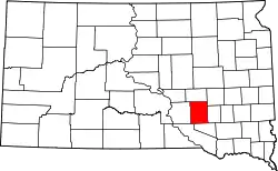 Karte von Aurora County innerhalb von South Dakota | |
Geschichte
Das Aurora County wurde am 22. Februar 1879 gebildet und am 29. August 1881 abschließend organisiert. Es wurde auf Vorschlag eines Literaturclubs, den die Frauen der ersten Siedler gegründet hatten, nach der römischen Göttin der Morgendämmerung benannt.[2] Plankinton wurde County Seat, eine Tat, die im November 1882 von den Wählern ratifiziert wurde.

Neun Bauwerke und Stätten des Countys sind im National Register of Historic Places (NRHP) eingetragen (Stand 29. Juli 2018).[3]
Geographie
Das County hat eine Fläche von 1845 Quadratkilometern. Davon sind 11 Quadratkilometer (0,61 Prozent) Wasserflächen. Es grenzt im Uhrzeigersinn an die Countys: Jerauld County, Sanborn County, Davison County, Douglas County, Charles Mix County und Brule County.
| Bevölkerungsentwicklung | |||
|---|---|---|---|
| Census | Einwohner | ± in % | |
| 1900 | 4011 | — | |
| 1910 | 6143 | 53,2 % | |
| 1920 | 7246 | 18 % | |
| 1930 | 7139 | −1,5 % | |
| 1940 | 5387 | −24,5 % | |
| 1950 | 5020 | −6,8 % | |
| 1960 | 4749 | −5,4 % | |
| 1970 | 4183 | −11,9 % | |
| 1980 | 3628 | −13,3 % | |
| 1990 | 3136 | −13,6 % | |
| 2000 | 3058 | −2,5 % | |
| 2010 | 2710 | −11,4 % | |
| 1900–1990[4]
2000[5] | |||
Townships
Die County wird in zwanzig Townships aufgeteilt:
|
|
|
|
|
Städte, Dörfer etc.
- Aurora Center, gemeindefreies Gebiet
- Plankinton, Stadt
- Stickney, Gemeinde
- Storla, census-designated place
- White Lake, Gemeinde
Einzelnachweise
- Aurora County im Geographic Names Information System des United States Geological Survey. Abgerufen am 22. Februar 2011
- Charles Curry Aiken, Joseph Nathan Kane: The American Counties: Origins of County Names, Dates of Creation, Area, and Population Data, 1950–2010. 6. Auflage. Scarecrow Press, Lanham 2013, ISBN 978-0-8108-8762-6, S. 13.
- Suchmaske Datenbank im National Register Information System. National Park Service, abgerufen am 29. Juli 2018.
- Auszug aus Census.gov. Abgerufen am 28. Februar 2011
- 2000 Census. Missouri Census Data Center, abgerufen am 20. Oktober 2021.
Weblinks
Liste der Countys in South Dakota
Aurora |
Beadle |
Bennett |
Bon Homme |
Brookings |
Brown |
Brule |
Buffalo |
Butte |
Campbell |
Charles Mix |
Clark |
Clay |
Codington |
Corson |
Custer |
Davison |
Day |
Deuel |
Dewey |
Douglas |
Edmunds |
Fall River |
Faulk |
Grant |
Gregory |
Haakon |
Hamlin |
Hand |
Hanson |
Harding |
Hughes |
Hutchinson |
Hyde |
Jackson |
Jerauld |
Jones |
Kingsbury |
Lake |
Lawrence |
Lincoln |
Lyman |
Marshall |
McCook |
McPherson |
Meade |
Mellette |
Miner |
Minnehaha |
Moody |
Oglala Lakota |
Pennington |
Perkins |
Potter |
Roberts |
Sanborn |
Spink |
Stanley |
Sully |
Todd |
Tripp |
Turner |
Union |
Walworth |
Yankton |
Ziebach