Lake County (South Dakota)
Lake County[1] ist ein County im Bundesstaat South Dakota der Vereinigten Staaten. Der Verwaltungssitz (County Seat) ist Madison.
.jpg.webp) Lake County Courthouse | |
| Verwaltung | |
|---|---|
| US-Bundesstaat: | South Dakota |
| Verwaltungssitz: | Madison |
| Gründung: | 1873 |
| Demographie | |
| Einwohner: | 11.200 (2010) |
| Bevölkerungsdichte: | 7,68 Einwohner/km2 |
| Geographie | |
| Fläche gesamt: | 1489 km² |
| Wasserfläche: | 31 km² |
| Karte | |
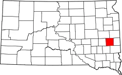 Karte von Lake County innerhalb von South Dakota | |
| Website: www.lakecountysd.com | |
Geographie
Das County hat eine Fläche von 1.489 Quadratkilometern; davon sind 31 Quadratkilometer (2,06 Prozent) Wasserflächen. Er grenzt im Uhrzeigersinn an die Countys Brookings County im Nordosten, Moody County, Minnehaha County, McCook County, Miner County und den Kingsbury County im Nordwesten.
Geschichte
Das County wurde am 8. Januar 1873 gegründet und ist nach den vielen Seen (eng.: “lakes”) in der Gegend benannt.[2]
15 Bauwerke und Stätten des Countys sind im National Register of Historic Places (NRHP) eingetragen (Stand 2. August 2018).[3]
Bevölkerungsentwicklung
| Bevölkerungsentwicklung | |||
|---|---|---|---|
| Census | Einwohner | ± in % | |
| 1900 | 9137 | — | |
| 1910 | 10.711 | 17,2 % | |
| 1920 | 12.257 | 14,4 % | |
| 1930 | 12.379 | 1 % | |
| 1940 | 12.412 | 0,3 % | |
| 1950 | 11.792 | −5 % | |
| 1960 | 11.764 | −0,2 % | |
| 1970 | 11.456 | −2,6 % | |
| 1980 | 10.724 | −6,4 % | |
| 1990 | 10.550 | −1,6 % | |
| 2000 | 11.276 | 6,9 % | |
| 2010 | 11.200 | −0,7 % | |
| 1900–1990[4]
2000[5] | |||
Townships
Der Bezirk teilt sich in 16 Townships: Badus, Chester, Clarno, Concord, Farmington, Franklin, Herman, Lake View, Le Roy, Nunda, Orland, Rutland, Summit, Wayne, Wentworth und Winfred.
Seen
Im Lake County gibt es mehrere Seen, die dem County seinen Namen gaben: Buffalo Slough, Brandt Lake, Davis Slough, Gilman Lake, Green Lake, Lake Badus, Lake Herman, Lake Madison, Long Lake, Mud Lake, Pelican Lake und der Round Lake.
Highways
Durch den Lake County führen folgende Highways:
 U.S. Highway 81
 South Dakota Highway 19
 South Dakota Highway 34
Weblinks
Einzelnachweise
- Lake County im Geographic Names Information System des United States Geological Survey. Abgerufen am 22. Februar 2011
- Charles Curry Aiken, Joseph Nathan Kane: The American Counties: Origins of County Names, Dates of Creation, Area, and Population Data, 1950–2010. 6. Auflage. Scarecrow Press, Lanham 2013, ISBN 978-0-8108-8762-6, S. 169.
- Suchmaske Datenbank im National Register Information System. National Park Service, abgerufen am 2. August 2018.
- Auszug aus Census.gov. Abgerufen am 28. Februar 2011
- Auszug aus factfinder.census.gov Abgerufen am 28. Februar 2011
Liste der Countys in South Dakota
Aurora |
Beadle |
Bennett |
Bon Homme |
Brookings |
Brown |
Brule |
Buffalo |
Butte |
Campbell |
Charles Mix |
Clark |
Clay |
Codington |
Corson |
Custer |
Davison |
Day |
Deuel |
Dewey |
Douglas |
Edmunds |
Fall River |
Faulk |
Grant |
Gregory |
Haakon |
Hamlin |
Hand |
Hanson |
Harding |
Hughes |
Hutchinson |
Hyde |
Jackson |
Jerauld |
Jones |
Kingsbury |
Lake |
Lawrence |
Lincoln |
Lyman |
Marshall |
McCook |
McPherson |
Meade |
Mellette |
Miner |
Minnehaha |
Moody |
Oglala Lakota |
Pennington |
Perkins |
Potter |
Roberts |
Sanborn |
Spink |
Stanley |
Sully |
Todd |
Tripp |
Turner |
Union |
Walworth |
Yankton |
Ziebach