Griscourt
| Griscourt | ||
|---|---|---|

|
| |
| Staat | Frankreich | |
| Region | Grand Est | |
| Département (Nr.) | Meurthe-et-Moselle (54) | |
| Arrondissement | Toul | |
| Kanton | Le Nord-Toulois | |
| Gemeindeverband | Bassin de Pont-à-Mousson | |
| Koordinaten | 48° 50′ N, 6° 1′ O | |
| Höhe | 197–281 m | |
| Fläche | 3,72 km² | |
| Einwohner | 137 (1. Januar 2019) | |
| Bevölkerungsdichte | 37 Einw./km² | |
| Postleitzahl | 54380 | |
| INSEE-Code | 54239 | |

Griscourt ist eine französische Gemeinde mit 137 Einwohnern (Stand: 1. Januar 2019) im Département Meurthe-et-Moselle in der Region Grand Est (vor 2016: Lothringen). Sie gehört zum Arrondissement Toul und zum Kanton Le Nord-Toulois. Die Einwohner werden Griscourtois genannt.
Geografie
Griscourt liegt etwa 22 Kilometer nordnordwestlich von Nancy. Umgeben wird Griscourt von den Nachbargemeinden Jezainville im Norden und Nordosten, Dieulouard im Osten, Villers-en-Haye im Süden sowie Gézoncourt im Westen.
Bevölkerungsentwicklung
| Jahr | 1962 | 1968 | 1975 | 1982 | 1990 | 1999 | 2006 | 2019 |
| Einwohner | 123 | 112 | 96 | 99 | 102 | 119 | 119 | 137 |
| Quellen: Cassini und INSEE | ||||||||
Sehenswürdigkeiten
- Kirche Saint-Martin aus dem 19. Jahrhundert
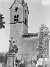
Kirche Saint-Martin 1914
This article is issued from Wikipedia. The text is licensed under Creative Commons - Attribution - Sharealike. The authors of the article are listed here. Additional terms may apply for the media files, click on images to show image meta data.