Grosrouvres
| Grosrouvres | ||
|---|---|---|

|
| |
| Staat | Frankreich | |
| Region | Grand Est | |
| Département (Nr.) | Meurthe-et-Moselle (54) | |
| Arrondissement | Toul | |
| Kanton | Le Nord-Toulois | |
| Gemeindeverband | Mad et Moselle | |
| Koordinaten | 48° 50′ N, 5° 50′ O | |
| Höhe | 230–260 m | |
| Fläche | 4,60 km² | |
| Einwohner | 57 (1. Januar 2019) | |
| Bevölkerungsdichte | 12 Einw./km² | |
| Postleitzahl | 54470 | |
| INSEE-Code | 54240 | |

Grosrouvres ist eine französische Gemeinde mit 57 Einwohnern (Stand: 1. Januar 2019) im Département Meurthe-et-Moselle in der Region Grand Est (vor 2016: Lothringen). Sie gehört zum Arrondissement Toul und zum Kanton Le Nord-Toulois.
Geografie
Grosrouvres liegt etwa 32 Kilometer nordwestlich von Nancy. Umgeben wird Grosrouvres von den Nachbargemeinden Bernécourt im Norden, Noviant-aux-Prés im Nordosten und Osten, Minorville im Osten und Südosten, Ansauville im Süden sowie Hamonville im Westen.
Bevölkerungsentwicklung
| Jahr | 1962 | 1968 | 1975 | 1982 | 1990 | 1999 | 2006 | 2019 |
| Einwohner | 55 | 58 | 53 | 44 | 51 | 46 | 51 | 57 |
| Quellen: Cassini und INSEE | ||||||||
Sehenswürdigkeiten
- Kirche Saint-Laurent aus dem 18. Jahrhundert
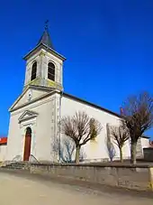
Kirche Saint-Laurent
This article is issued from Wikipedia. The text is licensed under Creative Commons - Attribution - Sharealike. The authors of the article are listed here. Additional terms may apply for the media files, click on images to show image meta data.