Maidières
| Maidières | ||
|---|---|---|
|
| |
| Staat | Frankreich | |
| Region | Grand Est | |
| Département (Nr.) | Meurthe-et-Moselle (54) | |
| Arrondissement | Nancy | |
| Kanton | Pont-à-Mousson | |
| Gemeindeverband | Bassin de Pont-à-Mousson | |
| Koordinaten | 48° 54′ N, 6° 2′ O | |
| Höhe | 182–305 m | |
| Fläche | 1,80 km² | |
| Einwohner | 1.547 (1. Januar 2019) | |
| Bevölkerungsdichte | 859 Einw./km² | |
| Postleitzahl | 54700 | |
| INSEE-Code | 54332 | |
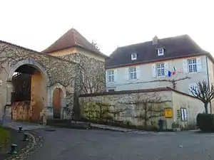 Schloss und Rathaus (Mairie) von Maidières | ||

Maidières ist eine französische Gemeinde mit 1.547 Einwohnern (Stand: 1. Januar 2019) im Département Meurthe-et-Moselle in der Region Grand Est (bis 2015 Lothringen). Sie gehört zum Arrondissement Nancy und zum Kanton Pont-à-Mousson.
Geografie
Maidières liegt etwa 25 Kilometer nordnordwestlich von Nancy. Umgeben wird Maidières von den Nachbargemeinden Montauville im Westen und Norden, Pont-à-Mousson im Norden und Osten sowie Blénod-lès-Pont-à-Mousson im Süden.
Die frühere Route nationale 58 (heutige D958) begrenzt die Gemeinde im Norden. Die Gemeinde liegt im Regionalen Naturpark Lothringen.
Bevölkerungsentwicklung
| Jahr | 1962 | 1968 | 1975 | 1982 | 1990 | 1999 | 2006 | 2019 |
| Einwohner | 1143 | 1564 | 1571 | 1447 | 1353 | 1366 | 1521 | 1547 |
Sehenswürdigkeiten
- Kirche Saint-Nicolas, romanischer Turm, im Übrigen aus dem 19. Jahrhundert
- Schloss Prochebois aus dem 18. Jahrhundert
- Schloss Casanova, Anfang des 18. Jahrhunderts erbaut
- Kapelle Notre-Dame-des-Anges (Casanova) aus dem 16. Jahrhundert
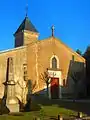 Kirche Saint-Nicolas
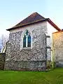 Kapelle Casanova
Weblinks
Commons: Maidières – Sammlung von Bildern, Videos und Audiodateien
This article is issued from Wikipedia. The text is licensed under Creative Commons - Attribution - Sharealike. The authors of the article are listed here. Additional terms may apply for the media files, click on images to show image meta data.