Montauville
| Montauville | ||
|---|---|---|
|
| |
| Staat | Frankreich | |
| Region | Grand Est | |
| Département (Nr.) | Meurthe-et-Moselle (54) | |
| Arrondissement | Nancy | |
| Kanton | Pont-à-Mousson | |
| Gemeindeverband | Bassin de Pont-à-Mousson | |
| Koordinaten | 48° 54′ N, 6° 1′ O | |
| Höhe | 193–376 m | |
| Fläche | 16,49 km² | |
| Einwohner | 1.078 (1. Januar 2019) | |
| Bevölkerungsdichte | 65 Einw./km² | |
| Postleitzahl | 54700 | |
| INSEE-Code | 54375 | |

Montauville ist eine französische Gemeinde mit 1.078 Einwohnern (Stand: 1. Januar 2019) im Département Meurthe-et-Moselle in der Region Grand Est (vor 2016: Lothringen). Sie gehört zum Arrondissement Nancy und zum Kanton Pont-à-Mousson. Die Einwohner werden Montauvillois genannt.
Geografie
Montauville liegt etwa 26 Kilometer nordnordwestlich von Nancy. Umgeben wird Montauville von den Nachbargemeinden Norroy-lès-Pont-à-Mousson im Norden, Pont-à-Mousson und Maidières im Osten, Blénod-lès-Pont-à-Mousson im Südosten, Jezainville im Süden, Martincourt im Südwesten, Mamey im Südwesten und Westen sowie Fey-en-Haye im Westen und Nordwesten.
Die Gemeinde liegt im Regionalen Naturpark Lothringen.
Bevölkerungsentwicklung
| Jahr | 1962 | 1968 | 1975 | 1982 | 1990 | 1999 | 2006 | 2019 |
| Einwohner | 700 | 793 | 846 | 951 | 1078 | 1092 | 1162 | 1078 |
| Quellen: Cassini und INSEE | ||||||||
Sehenswürdigkeiten
- Kirche Sainte-Marie-Madeleine aus dem 19. Jahrhundert
- Französischer Nationalfriedhof aus dem Ersten Weltkrieg
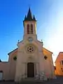 Kirche Sainte-Marie-Madeleine
 Französischer Nationalfriedhof
Weblinks
Commons: Montauville – Sammlung von Bildern, Videos und Audiodateien
This article is issued from Wikipedia. The text is licensed under Creative Commons - Attribution - Sharealike. The authors of the article are listed here. Additional terms may apply for the media files, click on images to show image meta data.