NUTS:UK
Als NUTS:UK oder NUTS-Regionen in dem Vereinigten Königreich bezeichnet man die territoriale Gliederung des Vereinigten Königreichs gemäß der europäischen „Systematik der Gebietseinheiten für die Statistik“ (NUTS).
Grundlagen
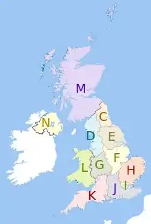
Im Vereinigten Königreich werden die drei NUTS-Ebenen wie folgt belegt:
- NUTS-1: Regionen
- NUTS-2: Grafschaften
- NUTS-3: Districts und Boroughs
NUTS-Codes
NUTS-1 • NUTS-2 • NUTS-3 • LAU
Mitgliedstaaten der Europäischen Union:
Belgien •
Bulgarien •
Dänemark •
Deutschland •
Estland •
Finnland •
Frankreich •
Griechenland •
Irland •
Italien •
Kroatien •
Lettland •
Litauen •
Luxemburg •
Malta •
Niederlande •
Österreich •
Polen •
Portugal •
Rumänien •
Schweden •
Slowenien •
Slowakei •
Spanien •
Tschechien •
Ungarn •
Zypern
Ehemalige:
Vereinigtes Königreich
Assoziierte:
Island •
Liechtenstein •
Norwegen •
Schweiz
Beitrittskandidaten:
Albanien •
Nordmazedonien •
Montenegro •
Serbien •
Türkei
Sortierung nach Ländercode:
AL •
AT •
BE •
BG •
CH •
CY •
CZ •
DE •
DK •
EE •
EL •
ES •
FI •
FR •
GR •
HR •
HU •
IE •
IS •
IT •
LI •
LT •
LU •
LV •
ME •
MK •
MT •
NL •
NO •
PL •
PT •
RO •
RS •
SE •
SI •
SK •
TR •
UK
Weblinks
- Metadata Download NUTS (Nomenclature of Territorial Units for Statistics), by regional level (NUTS) accessed 11 June 2012
- Overview map of EU Countries – NUTS level 1
- Correspondence between the NUTS levels and the national administrative units
- List of current NUTS codes
- Divisions of the United Kingdom, Statoids.com
- Listings of subdivisions of NUTS / LAU areas, Office for National Statistics, accessed 6 September 2012
- National Statistics Introduction to NUTS- dead link
- Eurostat Introduction to NUTS classification