Argyll and Bute
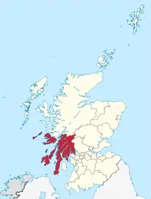
Argyll and Bute (gälisch: Earra-Ghàidheal agus Bòd) ist eine von 32 Council Areas in Schottland. Sie grenzt an Highland, Perth and Kinross, Stirling und West Dunbartonshire. Die östliche Grenze verläuft durch den Loch Lomond. Der Verwaltungssitz ist in Lochgilphead.
| Argyll and Bute Earra-Ghàidheal agus Bòd | |
|---|---|
 Argyll and Bute | |
| Verwaltungssitz | Lochgilphead |
| Fläche | 6.909 km² (2.) |
| Einwohner | 88.166[1] (26.) |
| ISO 3166-2 | GB-AGB |
| ONS-Code | 00QD |
| Website | www.argyll-bute.gov.uk |
Der größte Teil des Verwaltungsbezirks gehörte einst zur traditionellen Grafschaft Argyll, mit Ausnahme der Region Morvern nördlich von Mull, das heute zu Highland gehört. Der Bezirk umfasst auch die im Firth of Clyde liegende Isle of Bute, die zur traditionellen Grafschaft Bute gehörte sowie den westlichen Teil der traditionellen Grafschaft Dunbartonshire.
Orte
- Achahoish
- Appin
- Ardbeg
- Ardentinny
- Ardfern
- Ardlui
- Ardmore
- Ardnave
- Ardrishaig
- Ardtalla
- Arduaine
- Arrochar
- Ascog
- Auchindrain
- Baille Mór
- Ballivicar
- Ballygrant
- Barcaldine
- Bellochantuy
- Benderloch
- Bowmore
- Bridge of Orchy
- Bridgend
- Bruichladdich
- Cairndow
- Campbeltown
- Cardross
- Carradale
- Clynder
- Coillabus
- Cove
- Craighouse
- Craignure
- Crinan
- Cullipool
- Dalmally
- Dunbeg
- Dunoon
- Edentaggart
- Feolin
- Furnace
- Garelochhead
- Glendaruel
- Glenegedale
- Helensburgh
- Innellan
- Inveraray
- Keills
- Kilchiaran
- Kilchoman
- Kilcreggan
- Kilmartin
- Kilmeny
- Kilmoluaig
- Kilmore
- Kilmory
- Kilmun
- Kilnaughton
- Kilnave
- Kintour
- Kintra
- Lagavulin
- Lagg
- Laphroaig
- Lochdon
- Lochgilphead
- Lochgoilhead
- Lochindaal
- Lossit
- Lower Killeyan
- Luss
- Millhouse
- Muasdale
- Oban
- Peninver
- Persabus
- Port Appin
- Port Askaig
- Port Bannatyne
- Port Ellen
- Port Wemyss
- Portnahaven
- Rhu
- Rothesay
- Saddell
- Salen
- Sanaigmore
- Sandbank
- Skipness
- Southend
- Strone
- Tarbert (Jura)
- Tarbert (Kintyre)
- Tarbet
- Tayinloan
- Taynuilt
- Tobermory
Sehenswürdigkeiten
- Argyll Forest Park
- Arduaine Garden
- Caisteal Suidhe Cheannaidh ein gut erhaltenes Dun
- Carrick Castle
- Cruachan Dam
- Fincharn Castle
- Fingal’s Cave
- Gare Loch
- Kilchurn Castle
- Lachlan Castle
- Loch Lomond
- Old Lachlan Castle
- Strontoiller
- Benmore Botanic Garden
Inseln
Politik
Seit den Lokalwahlen 2017 setzt sich der 36 Sitze umfassende Council von Argyll and Bute wie folgt zusammen:[2]
| Partei | Sitze |
|---|---|
| Scottish National Party | 11 |
| Unabhängig | 10 |
| Liberal Democrats | 9 |
| Scottish Conservatives | 6 |
Partnerschaft
Seit 1967 besteht eine Partnerschaft mit dem Landkreis Amberg-Sulzbach in Bayern.
Weblinks
Einzelnachweise
- Zensus 2011
- Argyll and Bute Council: Wahlergebnisse 2017 (Abgerufen am 8. Juli 2017)
Aberdeen | Aberdeenshire | Angus | Argyll and Bute | Clackmannanshire | Dumfries and Galloway | Dundee | East Ayrshire | East Dunbartonshire | East Lothian | East Renfrewshire | Edinburgh | Falkirk | Fife | Glasgow | Highland | Inverclyde | Midlothian | Moray | Äußere Hebriden | North Ayrshire | North Lanarkshire | Orkney | Perth and Kinross | Renfrewshire | Scottish Borders | Shetland | South Ayrshire | South Lanarkshire | Stirling | West Dunbartonshire | West Lothian