Derry (District)
Derry (irisch Doire) war einer der 26 nordirischen Districts, die von 1973 bis 2015 bestanden, und lag in der traditionellen Grafschaft Londonderry. Der Distrikt wurde 1973 gebildet aus dem County Borough Londonderry, das die eigentliche Stadt Derry bzw. Londonderry umfasste, und dem Rural District Londonderry, zu dem das ländlich geprägte Umland gehörte. Neben der Stadt Derry lagen heute unter anderem die Orte Culmore, Newbuildings, Strathfoyle und Eglinton im District.
| Derry District Ceantar Dhoire | |
|---|---|
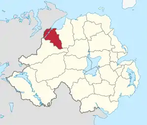 Lage in Nordirland | |
| Geografie | |
| Traditionelle Grafschaft | County Londonderry |
| Fläche | 378 km² |
| Verwaltungssitz | Derry bzw. Londonderry |
| ISO 3166-2 | GB-DRY |
| Demografie | |
| Bevölkerung | 108.586 (2012)[1] |
| Dichte | 287 Ew./km² |
| Konfessionen | Protestanten 19,4 % Katholiken 67,4 %[2] |
| Verwaltung | |
| Wahlbezirke | Cityside, Northland, Rural, Shantallow und Waterside |
Der 1973 gebildete Distrikt hieß zunächst Londonderry, wurde 1984 jedoch amtlich in Derry umbenannt. Da die eigentliche Stadt Derry den Status einer City besitzt, trug die Verwaltungsbehörde des gesamten Distrikts die Bezeichnung Derry City Council.
Zum 1. April 2015 ging Derry im neuen District Derry and Strabane auf.
Derry City Council
Die Wahl zum Derry City Council am 11. Mai 2011 hatte folgendes Ergebnis:[3]
| Partei | Ergebnis 2011 | Veränderung zu 2005 | |||
|---|---|---|---|---|---|
| Sitze | Stimmen | Sitze | Stimmen | ||
| Social Democratic and Labour Party (SDLP) | 14 | 38,2 % | 0 | −2,9 % | |
| Sinn Féin | 10 | 33,9 % | 0 | 1,0 % | |
| Democratic Unionist Party (DUP) | 5 | 14,7 % | 0 | −1,5 % | |
| Ulster Unionist Party (UUP) | 1 | 4,0 % | 0 | −0,5 % | |
| Alliance Party | 0 | 0,9 % | 0 | 0,9 % | |
| Sonstige | 0 | 5,8 % | 0 | 5,8 % | |
Siehe auch
Einzelnachweise
- Northern Ireland Population Estimates 2012 (XLS-Datei)
- Northern Ireland Census 2011: Religion (administrative geographies)
- Wahlergebnis bei BBC News (Abgerufen am 26. Juli 2011)
Antrim | Ards | Armagh | Ballymena | Ballymoney | Banbridge | Belfast | Carrickfergus | Castlereagh | Coleraine | Cookstown | Craigavon | Derry | Down | Dungannon and South Tyrone | Fermanagh | Larne | Limavady | Lisburn | Magherafelt | Moyle | Newry and Mourne | Newtownabbey | North Down | Omagh | Strabane