Banbridge (District)
Banbridge (irisch Droichead na Banna) war einer der 26 nordirischen Districts, die von 1973 bis 2015 bestanden. Der District, dessen Gebiet in der traditionellen Grafschaft Down lag, wurde 1973 eingerichtet. Bedeutende Orte im District waren die Stadt Banbridge, die auch Verwaltungssitz war, sowie Gilford, Loughbrickland und Scarva. Zum 1. April 2015 ging er im neuen District Armagh, Banbridge and Craigavon auf, wobei sein östlicher Teil Newry, Mourne and Down zugeschlagen wurde.[3]
| Banbridge District Ceantar Dhroichead na Banna | |
|---|---|
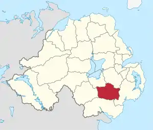 Lage in Nordirland | |
| Geografie | |
| Traditionelle Grafschaft | County Down |
| Fläche | 453 km² |
| Verwaltungssitz | Banbridge |
| ISO 3166-2 | GB-BNB |
| Demografie | |
| Bevölkerung | 48.730 (2012)[1] |
| Dichte | 108 Ew./km² |
| Konfessionen | Protestanten: 55,3 % Katholiken: 29,5 %[2] |
Banbridge Council
Die Wahl zum Banbridge Council am 11. Mai 2011 hatte folgendes Ergebnis:[4]
| Partei | Ergebnis 2011 | Veränderung zu 2005 | |||
|---|---|---|---|---|---|
| Sitze | Stimmen | Sitze | Stimmen | ||
| Ulster Unionist Party (UUP) | 7 | 33,8 % | 2 | 1,4 % | |
| Democratic Unionist Party (DUP) | 5 | 32,4 % | −2 | −6,0 % | |
| Social Democratic and Labour Party (SDLP) | 2 | 13,2 % | −1 | −2,6 % | |
| Sinn Féin | 2 | 11,4 % | 1 | 5,1 % | |
| Alliance Party | 1 | 4,9 % | 0 | 0,4 % | |
| Traditional Unionist Voice | 0 | 2,5 % | 0 | 2,5 % | |
Siehe auch
Einzelnachweise
- Northern Ireland Population Estimates 2012 (XLS-Datei)
- Northern Ireland Census 2011: Religion (administrative geographies)
- Karte der neuen und alten Districts (Memento vom 23. September 2015 im Internet Archive) des Department of the Environment, abgerufen am 6. Oktober 2015
- Wahlergebnis bei BBC News (Abgerufen am 26. Juli 2011)
Antrim | Ards | Armagh | Ballymena | Ballymoney | Banbridge | Belfast | Carrickfergus | Castlereagh | Coleraine | Cookstown | Craigavon | Derry | Down | Dungannon and South Tyrone | Fermanagh | Larne | Limavady | Lisburn | Magherafelt | Moyle | Newry and Mourne | Newtownabbey | North Down | Omagh | Strabane