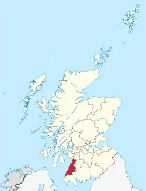
South Ayrshire
South Ayrshire (schottisch-gälisch Siorrachd Inbhir Àir a Deas) ist eine von 32 Council Areas in Schottland. Sie umfasst den südlichen Teil der traditionellen Grafschaft Ayrshire und grenzt an East Ayrshire sowie Dumfries and Galloway. Von 1975 bis 1996 bildete South Ayrshire unter dem Namen Kyle and Carrick einen District der Region Strathclyde.
| South Ayrshire Siorrachd Inbhir Àir a Deas | |
|---|---|
 South Ayrshire | |
| Verwaltungssitz | Ayr |
| Fläche | 1.222 km² (15.) |
| Einwohner | 112.910 (2012)[1] (19.) |
| ISO 3166-2 | GB-SAY |
| ONS-Code | 00RE |
| Website | www.south-ayrshire.gov.uk |
Orte
- Alloway
- Ayr
- Ballantrae
- Barr
- Barrhill
- Crosshill
- Dailly
- Dundonald
- Girvan
- Kirkmichael
- Kirkoswald
- Lendalfoot
- Maidens
- Maybole
- Monkton
- Old Dailly
- Prestwick
- Straiton
- Tarbolton
- Troon
- Turnberry
Sehenswürdigkeiten
- Ballast Bank
- Baltersan Castle
- Bargany Gardens
- Burns Cottage
- Burns National Heritage Park
- Carrick Forest
- Crossraguel Abbey
- Culzean Castle
- Dundonald Castle
- Girvan Beach
- Kildonan House
- Oswald's Temple
- Souter Johnnie’s Cottage
- Stinchar Bridge
- Turnberry Castle
- Turtle Rock
- siehe auch: Liste der Kategorie-A-Bauwerke in South Ayrshire
Politik
Der Council von South Ayrshire umfasst 28 Sitze, die sich wie folgt auf die Parteien verteilen:[2]
| Partei | Sitze |
|---|---|
| Conservative | 12 |
| Scottish National Party | 9 |
| Labour | 5 |
| Unabhängig | 2 |
Einzelnachweise
- Mid-2012 Population (Memento vom 29. November 2014 im Internet Archive) (PDF; 1,2 MB)
- Ergebnisse der Regionalwahlen 2017
Weblinks
Commons: South Ayrshire – Sammlung von Bildern, Videos und Audiodateien
This article is issued from Wikipedia. The text is licensed under Creative Commons - Attribution - Sharealike. The authors of the article are listed here. Additional terms may apply for the media files, click on images to show image meta data.