Derbyshire
Derbyshire [ˈdɑːbɪʃə] ist eine Grafschaft in den East Midlands von England.
| Grafschaft Derbyshire | |||
|---|---|---|---|
| |||
.svg.png.webp) Karte | |||
| Staat | Vereinigtes Königreich | ||
| Landesteil | England | ||
| Region | East Midlands | ||
| Status | Zeremonielle und Verwaltungsgrafschaft | ||
| Ersterwähnung | 1048 | ||
| Zeremonielle Grafschaft | |||
| Fläche | 2.625 km² | ||
| Einwohner | 1.053.316 | ||
| Stand | 30. Juni 2018[1] | ||
| Verwaltungsgrafschaft | |||
| Verwaltungssitz | Matlock | ||
| ISO-3166-2 | GB-DBY | ||
| Fläche | 2.547 km² | ||
| Einwohner | 796.142[1] | ||
| Stand | 30. Juni 2018 | ||
| ONS-Code | 17 | ||
| GSS-Code | E10000007 | ||
| NUTS-Code | UKF12, UKF13 | ||
| Website | www.derbyshire.gov.uk | ||
Distrikte / Unitary Authorities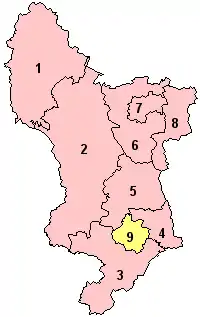 | |||
Geografie
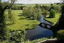
Die Grafschaft liegt in einer bergigen Landschaft. Der größte Teil des Peak-District-Nationalparks liegt innerhalb Derbyshires. Der nördliche Teil der Grafschaft überlappt sich mit den Pennines, einer berühmten Hügel- und Bergkette. Die Grafschaft hat Anteil am National Forest und grenzt an die Grafschaften und Gebiete des Greater Manchester, West Yorkshire, South Yorkshire, Nottinghamshire, Leicestershire, Staffordshire und Cheshire.
Neben dem County Council in Matlock bestehen acht District Councils in den einzelnen Kreisen. Trotz der Urbanisierung in 13 Städten zwischen 10.000 und 100.000 Einwohnern sind weite Teile des Gebietes ländlich geprägt: 75 % der Bevölkerung bewohnen 25 % der Fläche des Landes.
Bis 1998 war die Stadt Derby Teil der Grafschaft, ist nunmehr aber autonomer Stadtkreis (Unitary Authority).
Städte und Ortschaften
- Alfreton, Alton, Alport, Ashbourne, Ashford-in-the-Water
- Bakewell, Bamford, Baslow, Beeley, Belper, Biggin, Birch Vale, Blackshaw Moor, Bolehill, Bolsover, Borrowash, Brandside, Bretby, Brimington, Burbage, Burnaston, Buxton, Brough and Shatton
- Calver, Castleton, Chapel-en-le-Frith, Charlesworth, Chelmorton, Chesterfield, Clay Cross, Clowne, Cranborne, Cressbrook, Creswell, Crich, Cromford, Crowden, Curbar
- Darley Dale, Derby, Dove Holes, Dronfield, Duffield
- Earl Sterndale, Eckington, Edale, Edensor, Eyam
- Fenny Bentley, Fernilee
- Gamesley, Glossop, Great Hucklow, Great Longstone, Grindleford
- Hackney, Hadfield, Hartington, Hassop, Hathersage, Hayfield, Heage, Heanor, Hilton, Hope, Hurdlow
- Ilkeston
- Little Hucklow, Litton, Long Eaton
- Marston Montgomery, Marston on Dove, Matlock, Matlock Bath, Melbourne, Middleton, Milldale, Miller's Dale, Morley
- Nether Padley, New Mills, Newhaven
- Osmaston, Over Haddon
- Peak Forest, Pilsley, Priestcliffe
- Repton, Riber, Ripley, Rowsley
- Sheldon, Shipley, Shirebrook, Stackhall, Stanton by Bridge, Staveley, Stoney Middleton, Stretton, Sudbury, Swadlincote
- Taddington, Tansley, Taxal, Thornhill, Thorpe, Tibshelf, Tideswell, Tissington, Tunstead Milton
- Walton-on-Trent, Wardlow, Whaley Bridge, Whitwell, Wirksworth, Woodhead
- Youlgreave
Sehenswürdigkeiten
- Alfreton Hall
- Alsop Hall
- Arbor Low Henge, Teil von English Heritage
- Bamford Edge
- Barlborough Hall
- Blue John Cavern, Höhle nahe Castleton
- Calke Abbey, Teil des National Trust
- Calver Weir
- Cave Dale, Tal im Peak District National Park
- Chatsworth House
- Chrome Hill, Kalkstein Hügel
- National Tramway Museum, Straßenbahnmuseum in Crich
- Curbar Edge
- Derby Cathedral
- Derby Industrial Museum
- Derwent Edge
- Derwent Reservoir
- Derwent Valley Mills, Weltkulturerbe
- Haddon Hall
- Harborough Rocks, Kalkstein Hügel nahe Brassington
- Hardwick Hall
- Headstone Viaduct, Viadukt im Monsal Dale
- Hob Hurst's House, Teil von English Heritage
- Howden Reservoir
- Kedleston Hall
- Kinder Scout
- Ladybower Tor
- Ladybower Reservoir
- Magpie Mine
- Mam Tor
- Melbourne Hall
- Monsal Dale, Tal im Peak District National Park
- Nine Ladies
- Padley Gorge
- Peak Cavern, Höhle in Castleton
- Peveril Castle
- Riber Castle
- Speedwell Cavern, Höhle in Castleton
- St. Mary and All Saints', Kirche in Chesterfield
- Stanage Edge – Geländesteilhang mit der längsten Kletterroute Großbritanniens
- Sutton Scarsdale Hall, Teil von English Heritage
- Willersley Castle
- Win Hill
- Wingfield Manor, Teil von English Heritage
Kulinarische Spezialitäten
- Ashbourne Gingerbread
- Bakewell Pudding
- Buxton Pudding
- Derbyshire Oatcakes, Haferkekse
- Hartington Stilton, ein Stilton (Käse) aus Hartington
Sonstiges
Seit den 1970er Jahren findet in Derbyshire jährlich die Weltmeisterschaft im Zehenwrestling statt.[2]
Weblinks
Einzelnachweise
- Mid 2018 Estimates of the population for the UK, England and Wales, Scotland and Northern Ireland
- Von den Socken: Weltmeisterschaft im Zehen-Wrestling, auf faz.net, vom 19. Juni 2015. Abgerufen am 27. Mai 2019.
Bedfordshire | Berkshire | Buckinghamshire | Cambridgeshire | Cheshire | Cornwall | Cumberland | Derbyshire | Devon | Dorset | Durham | Essex | Gloucestershire | Hampshire | Herefordshire | Hertfordshire | Huntingdonshire | Kent | Lancashire | Leicestershire | Lincolnshire | Middlesex | Norfolk | Northamptonshire | Northumberland | Nottinghamshire | Oxfordshire | Rutland | Shropshire | Somerset | Staffordshire | Suffolk | Surrey | Sussex | Warwickshire | Westmorland | Wiltshire | Worcestershire | Yorkshire
Grafschaften Englands mit zweistufiger Verwaltung (Non-Metropolitan Counties)
Cambridgeshire |
Cumbria |
Derbyshire |
Devon |
East Sussex |
Essex |
Gloucestershire |
Hampshire |
Hertfordshire |
Kent |
Lancashire |
Leicestershire |
Lincolnshire |
Norfolk |
North Yorkshire |
Nottinghamshire |
Oxfordshire |
Somerset |
Staffordshire |
Suffolk |
Surrey |
Warwickshire |
West Sussex |
Worcestershire
Unitary Authorities
mit County Status
Bath and North East Somerset |
Bedford |
Blackburn with Darwen |
Blackpool |
Bournemouth, Christchurch and Poole |
Brighton and Hove |
Bristol |
Buckinghamshire |
Central Bedfordshire |
Cheshire East |
Cheshire West and Chester |
Cornwall |
County Durham |
Darlington |
Derby |
Dorset |
East Riding of Yorkshire |
Halton |
Hartlepool |
Herefordshire |
Isle of Wight |
Kingston upon Hull |
Leicester |
Luton |
Medway |
Middlesbrough |
Milton Keynes |
North East Lincolnshire |
North Lincolnshire |
North Northamptonshire |
North Somerset |
Northumberland |
Nottingham |
Peterborough |
Plymouth |
Portsmouth |
Redcar and Cleveland |
Rutland |
Shropshire |
Southampton |
Southend-on-Sea |
South Gloucestershire |
Stockton-on-Tees |
Stoke-on-Trent |
Swindon |
Telford and Wrekin |
Thurrock |
Torbay |
Warrington |
West Northamptonshire |
Wiltshire |
York
ohne County Status
Bracknell Forest |
Reading |
Slough |
West Berkshire |
Windsor and Maidenhead |
Wokingham
sui generis, ohne County Status
Isles of Scilly
Bedfordshire | Berkshire | Bristol | Buckinghamshire | Cambridgeshire | Cheshire | City of London | Cornwall | Cumbria | Derbyshire | Devon | Dorset | Durham | East Riding of Yorkshire | East Sussex | Essex | Gloucestershire | Greater London | Greater Manchester | Hampshire | Herefordshire | Hertfordshire | Isle of Wight | Kent | Lancashire | Leicestershire | Lincolnshire | Merseyside | Norfolk | North Yorkshire | Northamptonshire | Northumberland | Nottinghamshire | Oxfordshire | Rutland | Shropshire | Somerset | South Yorkshire | Staffordshire | Suffolk | Surrey | Tyne and Wear | Warwickshire | West Midlands | West Sussex | West Yorkshire | Wiltshire | Worcestershire