Villiers-le-Roux
Villiers-le-Roux ist eine französische Gemeinde mit 136 Einwohnern (Stand: 1. Januar 2019) im Département Charente in der Region Nouvelle-Aquitaine (vor 2016 Poitou-Charentes); sie gehört zum Arrondissement Confolens und zum Kanton Charente-Nord (bis 2015 Villefagnan). Die Einwohner werden Villelarosiens oder Rouxinvillois genannt.
| Villiers-le-Roux | ||
|---|---|---|
| ||
| Staat | Frankreich | |
| Region | Nouvelle-Aquitaine | |
| Département (Nr.) | Charente (16) | |
| Arrondissement | Confolens | |
| Kanton | Charente-Nord | |
| Gemeindeverband | Val de Charente | |
| Koordinaten | 46° 3′ N, 0° 6′ O | |
| Höhe | 115–137 m | |
| Fläche | 4,95 km² | |
| Einwohner | 136 (1. Januar 2019) | |
| Bevölkerungsdichte | 27 Einw./km² | |
| Postleitzahl | 16240 | |
| INSEE-Code | 16413 | |
 Rathaus (Mairie) von Villiers-le-Roux | ||

Geographie
Villiers-le-Roux liegt etwa 38 Kilometer nordnordwestlich von Angoulême und wird umgeben von den Nachbargemeinden Montjean im Norden, Saint-Martin-du-Clocher im Nordosten, La Chèvrerie im Osten und Südosten, Villefagnan im Süden sowie La Magdeleine im Westen.
Bevölkerungsentwicklung
| Jahr | 1793 | 1856 | 1901 | 1962 | 1968 | 1975 | 1982 | 1990 | 1999 | 2006 | 2013 |
|---|---|---|---|---|---|---|---|---|---|---|---|
| Einwohner | 400 | 387 | 309 | 170 | 153 | 117 | 121 | 123 | 140 | 127 | 137 |
| Quelle: Cassini und INSEE | |||||||||||
Sehenswürdigkeiten
- Kirche Saint-Pierre-aux-Liens
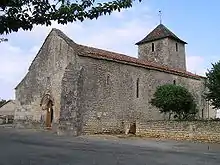
Kirche Saint-Pierre-aux-Liens
This article is issued from Wikipedia. The text is licensed under Creative Commons - Attribution - Sharealike. The authors of the article are listed here. Additional terms may apply for the media files, click on images to show image meta data.