Villejoubert
Villejoubert ist eine französische Gemeinde mit 338 Einwohnern (Stand 1. Januar 2019) im Département Charente in der Region Nouvelle-Aquitaine (vor 2016 Poitou-Charentes); sie gehört zum Arrondissement Confolens (bis 2017 Angoulême) und zum Kanton Boixe-et-Manslois (bis 2015 Saint-Amant-de-Boixe).
| Villejoubert | ||
|---|---|---|
| ||
| Staat | Frankreich | |
| Region | Nouvelle-Aquitaine | |
| Département (Nr.) | Charente (16) | |
| Arrondissement | Confolens | |
| Kanton | Boixe-et-Manslois | |
| Gemeindeverband | Cœur de Charente | |
| Koordinaten | 45° 51′ N, 0° 11′ O | |
| Höhe | 73–146 m | |
| Fläche | 7,89 km² | |
| Einwohner | 338 (1. Januar 2019) | |
| Bevölkerungsdichte | 43 Einw./km² | |
| Postleitzahl | 16560 | |
| INSEE-Code | 16412 | |
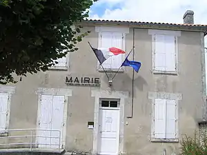 Rathaus (Mairie) von Villejoubert | ||

Geographie
Villejoubert liegt etwa 25 Kilometer nordnordwestlich von Angoulême. Umgeben wird Villejoubert von den Nachbargemeinden Saint-Amant-de-Boixe im Norden, Süden und Westen, Aussac-Vadalle im Norden und Osten sowie Tourriers im Osten und Südosten.
Bevölkerungsentwicklung
| 1962 | 1968 | 1975 | 1982 | 1990 | 1999 | 2006 | 2013 |
|---|---|---|---|---|---|---|---|
| 139 | 127 | 165 | 256 | 279 | 293 | 326 | 337 |
| Quelle: Cassini und INSEE | |||||||
Sehenswürdigkeiten
- Kirche Saint-Lazare, seit 1934 Monument historique
- Kapelle La Mascarine aus dem 11. Jahrhundert
- Reste des Castrums von Andone aus gallorömischer Zeit (später vermutlich karolingische Festung), Monument historique seit 1986
- Schloss La Barre aus dem 15. Jahrhundert, Monument historique seit 1990
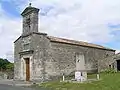 Kirche Saint-Lazare
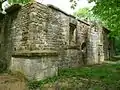 Kapelle La Mascarine
 Castrum Andone
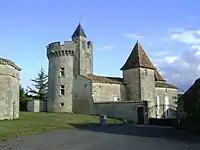 Schloss La Barre
This article is issued from Wikipedia. The text is licensed under Creative Commons - Attribution - Sharealike. The authors of the article are listed here. Additional terms may apply for the media files, click on images to show image meta data.