Saint-Gourson
Saint-Gourson ist eine französische Gemeinde mit 132 Einwohnern (Stand: 1. Januar 2019) im Département Charente in der Region Nouvelle-Aquitaine (vor 2016 Poitou-Charentes); sie gehört zum Arrondissement Confolens und zum Kanton Charente-Nord (bis 2015 Ruffec). Die Einwohner werden Saint-Goursonnais genannt.
| Saint-Gourson | ||
|---|---|---|
| ||
| Staat | Frankreich | |
| Region | Nouvelle-Aquitaine | |
| Département (Nr.) | Charente (16) | |
| Arrondissement | Confolens | |
| Kanton | Charente-Nord | |
| Gemeindeverband | Val de Charente | |
| Koordinaten | 45° 57′ N, 0° 19′ O | |
| Höhe | 89–161 m | |
| Fläche | 10,05 km² | |
| Einwohner | 132 (1. Januar 2019) | |
| Bevölkerungsdichte | 13 Einw./km² | |
| Postleitzahl | 16700 | |
| INSEE-Code | 16325 | |
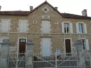 Rathaus (Mairie) von Saint-Gourson | ||

Geographie
Saint-Gourson liegt etwa 32 Kilometer nordnordöstlich von Angoulême. Saint-Gourson wird umgeben von den Nachbargemeinden Nanteuil-en-Vallée im Norden, Chassiecq im Osten, Saint-Sulpice-de-Ruffec im Süden, Couture im Süden und Südwesten sowie Poursac im Westen und Nordwesten.
Bevölkerungsentwicklung
| Jahr | 1793 | 1856 | 1901 | 1962 | 1968 | 1975 | 1982 | 1990 | 1999 | 2006 | 2013 |
|---|---|---|---|---|---|---|---|---|---|---|---|
| Einwohner | 539 | 536 | 449 | 262 | 232 | 170 | 179 | 147 | 136 | 128 | 142 |
| Quelle: Cassini und INSEE | |||||||||||
Sehenswürdigkeiten
- Kirche Saint-Pierre aus dem 12. Jahrhundert, Monument historique seit 1933
- Schloss Domezac
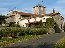
Kirche Saint-Pierre
This article is issued from Wikipedia. The text is licensed under Creative Commons - Attribution - Sharealike. The authors of the article are listed here. Additional terms may apply for the media files, click on images to show image meta data.