Montrollet
Montrollet ist eine französische Gemeinde mit 321 Einwohnern (Stand 1. Januar 2019) im Département Charente in der Region Nouvelle-Aquitaine. Sie gehört zum Arrondissement Confolens und zum Kanton Charente-Vienne. Die Bewohner nennen sich Montrolletois, Montrolletoises, Monteirollais oder Monteirollaises.
| Montrollet | ||
|---|---|---|
| ||
| Staat | Frankreich | |
| Region | Nouvelle-Aquitaine | |
| Département (Nr.) | Charente (16) | |
| Arrondissement | Confolens | |
| Kanton | Charente-Vienne | |
| Gemeindeverband | Charente Limousine | |
| Koordinaten | 45° 59′ N, 0° 54′ O | |
| Höhe | 225–368 m | |
| Fläche | 22,08 km² | |
| Einwohner | 321 (1. Januar 2019) | |
| Bevölkerungsdichte | 15 Einw./km² | |
| Postleitzahl | 16420 | |
| INSEE-Code | 16231 | |
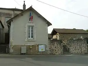 Mairie Montrollet | ||

Geographie
Montrollet ist die östlichste Gemeinde des Départements Charente. Sie grenzt im Norden an Nouic, im Nordosten an Montrol-Sénard, im Südosten an Javerdat, im Süden an Brigueuil und im Westen sowie im Nordwesten an Saint-Christophe.
Bevölkerungsentwicklung
| Jahr | 1962 | 1968 | 1975 | 1982 | 1990 | 1999 | 2008 | 2013 |
|---|---|---|---|---|---|---|---|---|
| Einwohner | 428 | 406 | 343 | 296 | 265 | 269 | 294 | 305 |
Sehenswürdigkeiten
- Kirche Saint-Sulpice
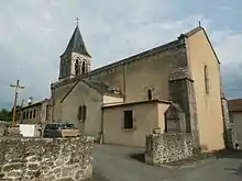
Kirche Saint-Sulpice
This article is issued from Wikipedia. The text is licensed under Creative Commons - Attribution - Sharealike. The authors of the article are listed here. Additional terms may apply for the media files, click on images to show image meta data.