Saint-Mary
Saint-Mary ist eine französische Gemeinde mit 343 Einwohnern (Stand: 1. Januar 2019) im Département Charente in der Region Nouvelle-Aquitaine (vor 2016 Poitou-Charentes); sie gehört zum Arrondissement Confolens und zum Kanton Charente-Bonnieure (bis 2015 Saint-Claud). Die Einwohner werden Mariussois genannt.
| Saint-Mary Sent Mari | ||
|---|---|---|
| ||
| Staat | Frankreich | |
| Region | Nouvelle-Aquitaine | |
| Département (Nr.) | Charente (16) | |
| Arrondissement | Confolens | |
| Kanton | Charente-Bonnieure | |
| Gemeindeverband | Charente Limousine | |
| Koordinaten | 45° 50′ N, 0° 23′ O | |
| Höhe | 75–183 m | |
| Fläche | 21,70 km² | |
| Einwohner | 343 (1. Januar 2019) | |
| Bevölkerungsdichte | 16 Einw./km² | |
| Postleitzahl | 16260 | |
| INSEE-Code | 16336 | |
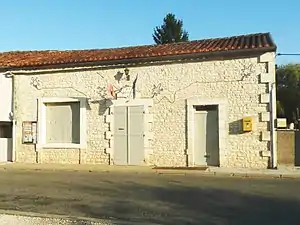 Rathaus (Mairie) von Saint-Mary | ||

Geographie
Saint-Mary liegt etwa 29 Kilometer nordöstlich von Angoulême. Saint-Mary wird umgeben von den Nachbargemeinden La Tâche im Norden, Cellefrouin im Norden und Nordosten, Chasseneuil-sur-Bonnieure im Osten und Südosten, Les Pins im Süden, Val-de-Bonnieure im Westen und Südwesten sowie Valence im Nordwesten.
Bevölkerungsentwicklung
| Jahr | 1793 | 1856 | 1901 | 1962 | 1968 | 1975 | 1982 | 1990 | 1999 | 2006 | 2013 |
|---|---|---|---|---|---|---|---|---|---|---|---|
| Einwohner | 1.020 | 882 | 606 | 452 | 468 | 371 | 315 | 373 | 365 | 367 | 357 |
| Quelle: Cassini und INSEE | |||||||||||
Sehenswürdigkeiten
- Kirche Saint-Mary, früheres Priorat
- Schloss Saint-Mary, 1751 erbaut
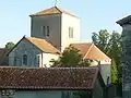 Kirche Saint-Mary
 Schloss Saint-Mary
This article is issued from Wikipedia. The text is licensed under Creative Commons - Attribution - Sharealike. The authors of the article are listed here. Additional terms may apply for the media files, click on images to show image meta data.