Saint-Groux
Saint-Groux ist eine französische Gemeinde mit 135 Einwohnern (Stand 1. Januar 2019) im Département Charente in der Region Nouvelle-Aquitaine (vor 2016 Poitou-Charentes); sie gehört zum Arrondissement Confolens und zum Kanton Boixe-et-Manslois.
| Saint-Groux | ||
|---|---|---|
| ||
| Staat | Frankreich | |
| Region | Nouvelle-Aquitaine | |
| Département (Nr.) | Charente (16) | |
| Arrondissement | Confolens | |
| Kanton | Boixe-et-Manslois | |
| Gemeindeverband | Cœur de Charente | |
| Koordinaten | 45° 54′ N, 0° 10′ O | |
| Höhe | 53–90 m | |
| Fläche | 4,43 km² | |
| Einwohner | 135 (1. Januar 2019) | |
| Bevölkerungsdichte | 30 Einw./km² | |
| Postleitzahl | 16230 | |
| INSEE-Code | 16326 | |
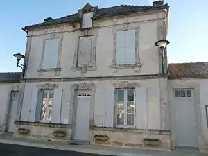 Rathaus (Mairie) von Saint-Groux | ||

Geographie
Saint-Groux liegt etwa dreißig Kilometer nördlich von Angoulême an der Charente. Umgeben wird Saint-Groux von den Nachbargemeinden Fontenille im Norden, Mansle im Osten und Südosten, Cellettes im Süden sowie Luxé im Westen.
Bevölkerungsentwicklung
| 1962 | 1968 | 1975 | 1982 | 1990 | 1999 | 2006 | 2018 |
|---|---|---|---|---|---|---|---|
| 104 | 84 | 91 | 94 | 114 | 122 | 132 | 136 |
| Quellen: Cassini und INSEE | |||||||
Sehenswürdigkeiten

Kirche Saint-Groux
- Kirche Saint-Groux
This article is issued from Wikipedia. The text is licensed under Creative Commons - Attribution - Sharealike. The authors of the article are listed here. Additional terms may apply for the media files, click on images to show image meta data.