Saint-Coutant (Charente)
| Saint-Coutant Sent Constanç | ||
|---|---|---|

|
| |
| Staat | Frankreich | |
| Region | Nouvelle-Aquitaine | |
| Département (Nr.) | Charente (16) | |
| Arrondissement | Confolens | |
| Kanton | Charente-Bonnieure | |
| Gemeindeverband | Charente Limousine | |
| Koordinaten | 46° 0′ N, 0° 28′ O | |
| Höhe | 133–197 m | |
| Fläche | 19,48 km² | |
| Einwohner | 216 (1. Januar 2019) | |
| Bevölkerungsdichte | 11 Einw./km² | |
| Postleitzahl | 16350 | |
| INSEE-Code | 16310 | |
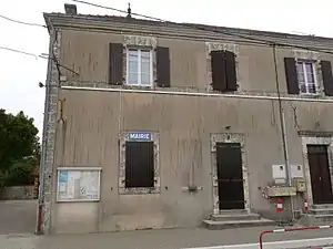 Rathaus (Mairie) von Saint-Coutant | ||

Saint-Coutant ist eine französische Gemeinde mit 216 Einwohnern (Stand: 1. Januar 2019) im Département Charente in der Region Nouvelle-Aquitaine (vor 2016 Poitou-Charentes); sie gehört zum Arrondissement Confolens und zum Kanton Charente-Bonnieure (bis 2015 Champagne-Mouton). Die Einwohner werden Saint-Coutantais genannt.
Geographie
Saint-Coutant liegt etwa 44 Kilometer nordnordöstlich von Angoulême. Saint-Coutant wird umgeben von den Nachbargemeinden Benest im Norden, Alloue im Osten und Nordosten, Ambernac im Südosten, Saint-Laurent-de-Céris im Süden, Le Vieux-Cérier im Westen und Südwesten sowie Champagne-Mouton im Westen und Nordwesten.
Bevölkerungsentwicklung
| Jahr | 1793 | 1856 | 1901 | 1962 | 1968 | 1975 | 1982 | 1990 | 1999 | 2006 | 2013 |
|---|---|---|---|---|---|---|---|---|---|---|---|
| Einwohner | 540 | 648 | 569 | 425 | 391 | 332 | 284 | 259 | 223 | 217 | 221 |
| Quelle: Cassini und INSEE | |||||||||||
Sehenswürdigkeiten
- Kirche Saint-Coutant aus dem 13. Jahrhundert
- Kapelle von Chabossant
- Priorat Saint-Gilles in Fontcreuse
- Schloss Puybautier aus dem 18. Jahrhundert, Monument historique seit 2001
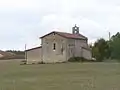 Kirche Saint-Coutant
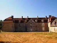 Schloss Puybautier
This article is issued from Wikipedia. The text is licensed under Creative Commons - Attribution - Sharealike. The authors of the article are listed here. Additional terms may apply for the media files, click on images to show image meta data.