Lupsault
Lupsault ist eine französische Gemeinde mit 104 Einwohnern (Stand: 1. Januar 2019) im Département Charente in der Region Nouvelle-Aquitaine (vor 2016 Poitou-Charentes); sie gehört zum Arrondissement Confolens und zum Kanton Charente-Nord (bis 2015 Aigre). Die Einwohner werden Supisultiens oder Lupsaultiens genannt.
| Lupsault | ||
|---|---|---|
| ||
| Staat | Frankreich | |
| Region | Nouvelle-Aquitaine | |
| Département (Nr.) | Charente (16) | |
| Arrondissement | Confolens | |
| Kanton | Charente-Nord | |
| Gemeindeverband | Cœur de Charente | |
| Koordinaten | 45° 57′ N, 0° 4′ W | |
| Höhe | 75–139 m | |
| Fläche | 11,43 km² | |
| Einwohner | 104 (1. Januar 2019) | |
| Bevölkerungsdichte | 9 Einw./km² | |
| Postleitzahl | 16140 | |
| INSEE-Code | 16194 | |
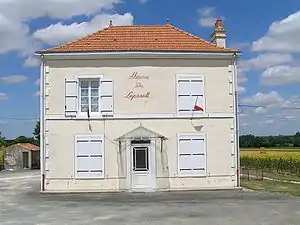 Rathaus (Mairie) von Lupsault | ||

Geographie
Lupsault liegt etwa 27 Kilometer nordnordwestlich von Angoulême und wird umgeben von den Nachbargemeinden Les Gours im Norden, Saint-Fraigne im Osten und Nordosten, Oradour im Süden und Südosten, Barbezières im Süden und Südwesten sowie Chives im Westen.
Bevölkerungsentwicklung
| Jahr | 1793 | 1856 | 1901 | 1962 | 1968 | 1975 | 1982 | 1990 | 1999 | 2006 | 2013 |
|---|---|---|---|---|---|---|---|---|---|---|---|
| Einwohner | 281 | 381 | 237 | 250 | 228 | 192 | 151 | 160 | 132 | 126 | 98 |
| Quelle: Cassini und INSEE | |||||||||||
Sehenswürdigkeiten
- Kirche Saint-Cybard aus dem 11. Jahrhundert, früheres Priorat, Monument historique
- Schloss Le Buchet aus dem Jahre 1484
- Herrenhaus von Gaillard aus dem 15. Jahrhundert
- Mühle von Louraud
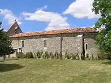
Kirche Notre-Dame
This article is issued from Wikipedia. The text is licensed under Creative Commons - Attribution - Sharealike. The authors of the article are listed here. Additional terms may apply for the media files, click on images to show image meta data.