Juillé (Charente)
Juillé ist eine französische Gemeinde mit 180 Einwohnern (Stand 1. Januar 2019) im Département Charente in der Region Nouvelle-Aquitaine (vor 2016 Poitou-Charentes); sie gehört zum Arrondissement Confolens und zum Kanton Boixe-et-Manslois (bis 2015 Mansle). Die Einwohner werden Juilléens genannt.
| Juillé | ||
|---|---|---|
| ||
| Staat | Frankreich | |
| Region | Nouvelle-Aquitaine | |
| Département (Nr.) | Charente (16) | |
| Arrondissement | Confolens | |
| Kanton | Boixe-et-Manslois | |
| Gemeindeverband | Cœur de Charente | |
| Koordinaten | 45° 56′ N, 0° 9′ O | |
| Höhe | 56–116 m | |
| Fläche | 8,69 km² | |
| Einwohner | 180 (1. Januar 2019) | |
| Bevölkerungsdichte | 21 Einw./km² | |
| Postleitzahl | 16230 | |
| INSEE-Code | 16173 | |
 Rathaus (Mairie) von Juillé | ||

Geographie
Juillé liegt etwa 32 Kilometer nördlich von Angoulême. Umgeben wird Juillé von den Nachbargemeinden Charmé im Norden und Nordwesten, Salles-de-Villefagnan im Norden und Nordosten, Lonnes im Osten und Nordosten, Fontenille im Süden und Osten, Luxé im Süden und Südwesten sowie Ligné im Westen und Südwesten.
Bevölkerungsentwicklung
| 1962 | 1968 | 1975 | 1982 | 1990 | 1999 | 2006 | 2013 |
|---|---|---|---|---|---|---|---|
| 265 | 232 | 218 | 206 | 198 | 181 | 185 | 192 |
| Quelle: Cassini und INSEE | |||||||
Sehenswürdigkeiten
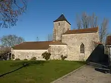
Kirche Saint-Jean-Baptiste
- Kirche Saint-Jean-Baptiste, früheres Priorat
This article is issued from Wikipedia. The text is licensed under Creative Commons - Attribution - Sharealike. The authors of the article are listed here. Additional terms may apply for the media files, click on images to show image meta data.