Suin (Saône-et-Loire)
Suin ist eine französische Gemeinde mit 257 Einwohnern (Stand: 1. Januar 2019) im Département Saône-et-Loire in der Region Bourgogne-Franche-Comté (vor 2016 Bourgogne). Sie gehört zum Arrondissement Charolles und zum Kanton Charolles (bis 2015: Kanton Saint-Bonnet-de-Joux).
| Suin | ||
|---|---|---|
| ||
| Staat | Frankreich | |
| Region | Bourgogne-Franche-Comté | |
| Département (Nr.) | Saône-et-Loire (71) | |
| Arrondissement | Charolles | |
| Kanton | Charolles | |
| Gemeindeverband | Grand Charolais | |
| Koordinaten | 46° 26′ N, 4° 28′ O | |
| Höhe | 310–600 m | |
| Fläche | 22,06 km² | |
| Einwohner | 257 (1. Januar 2019) | |
| Bevölkerungsdichte | 12 Einw./km² | |
| Postleitzahl | 71220 | |
| INSEE-Code | 71529 | |
 Rathaus (Mairie) von Suin | ||

Geographie
Suin liegt etwa 50 Kilometer südwestlich von Chalon-sur-Saône. Nachbargemeinden von Suin sind Saint-Bonnet-de-Joux im Norden, Pressey-sous-Dondin im Nordosten, Sivignon im Osten, Trivy im Südosten, Verosvres im Süden, Beaubery im Westen und Südwesten sowie Vendenesse-lès-Charolles im Westen und Nordwesten.
Bevölkerungsentwicklung
| Jahr | 1962 | 1968 | 1975 | 1982 | 1990 | 1999 | 2006 | 2011 | 2016 |
| Einwohner | 477 | 424 | 369 | 325 | 321 | 304 | 289 | 283 | 268 |
| Quelle: Cassini und INSEE | |||||||||
Sehenswürdigkeiten
- Kirche Notre-Dame-de-l'Assomption
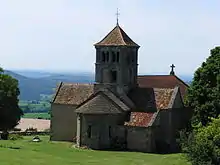
Kirche Notre-Dame-de-l'Assomption
This article is issued from Wikipedia. The text is licensed under Creative Commons - Attribution - Sharealike. The authors of the article are listed here. Additional terms may apply for the media files, click on images to show image meta data.