Volesvres
Volesvres ist eine französische Gemeinde mit 632 Einwohnern (Stand: 1. Januar 2019) im Département Saône-et-Loire in der Region Bourgogne-Franche-Comté. Sie gehört zum Arrondissement Charolles und zum Kanton Paray-le-Monial.
| Volesvres | ||
|---|---|---|
| ||
| Staat | Frankreich | |
| Region | Bourgogne-Franche-Comté | |
| Département (Nr.) | Saône-et-Loire (71) | |
| Arrondissement | Charolles | |
| Kanton | Paray-le-Monial | |
| Gemeindeverband | Grand Charolais | |
| Koordinaten | 46° 28′ N, 4° 10′ O | |
| Höhe | 239–307 m | |
| Fläche | 21,61 km² | |
| Einwohner | 632 (1. Januar 2019) | |
| Bevölkerungsdichte | 29 Einw./km² | |
| Postleitzahl | 71600 | |
| INSEE-Code | 71590 | |
| Website | https://www.volesvres.fr/ | |

Geographie
Volesvres liegt in der Landschaft Charolais am Bourbince und am Canal du Centre. Nachbargemeinden von Volesvres sind Saint-Vincent-Bragny im Norden und Nordwesten, Saint-Aubin-en-Charollais im Norden und Nordosten, Champlecy im Osten, Hautefond im Süden, Paray-le-Monial im Südwesten sowie Saint-Léger-lès-Paray im Westen.
Durch die Gemeinde führt die Route nationale 79.
Bevölkerungsentwicklung
| Jahr | 1962 | 1968 | 1975 | 1982 | 1990 | 1999 | 2006 | 2013 |
| Einwohner | 430 | 420 | 399 | 474 | 536 | 561 | 596 | 621 |
| Quelle: Cassini und INSEE | ||||||||
Sehenswürdigkeiten
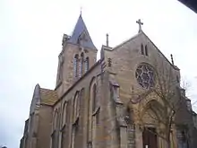
Kirche Saint-Jean-Baptiste
- Kirche Saint-Jean-Baptiste
- Schloss Cypierre
This article is issued from Wikipedia. The text is licensed under Creative Commons - Attribution - Sharealike. The authors of the article are listed here. Additional terms may apply for the media files, click on images to show image meta data.