Lugny-lès-Charolles
| Lugny-lès-Charolles | ||
|---|---|---|
.svg.png.webp)
|
| |
| Staat | Frankreich | |
| Region | Bourgogne-Franche-Comté | |
| Département (Nr.) | Saône-et-Loire (71) | |
| Arrondissement | Charolles | |
| Kanton | Charolles | |
| Gemeindeverband | Grand Charolais | |
| Koordinaten | 46° 25′ N, 4° 13′ O | |
| Höhe | 265–365 m | |
| Fläche | 16,85 km² | |
| Einwohner | 350 (1. Januar 2019) | |
| Bevölkerungsdichte | 21 Einw./km² | |
| Postleitzahl | 71120 | |
| INSEE-Code | 71268 | |
| Website | http://www.lugny-les-charolles.net/ | |
 Rathaus (Mairie) und Schule von Lugny-lès-Charolles | ||

Lugny-lès-Charolles ist eine französische Gemeinde mit 350 Einwohnern (Stand: 1. Januar 2019) im Département Saône-et-Loire in der Region Bourgogne-Franche-Comté (vor 2016 Bourgogne). Sie gehört zum Arrondissement Charolles und zum Kanton Charolles.
Geographie
Lugny-lès-Charolles liegt etwa 64 Kilometer südwestlich von Chalon-sur-Saône. Nachbargemeinden von Lugny-lès-Charolles sind Hautefond im Norden und Nordwesten, Champlecy im Norden und Nordosten, Changy im Osten, Saint-Julien-de-Civry im Süden sowie Nochize im Westen und Südwesten.
Bevölkerungsentwicklung
| Jahr | 1962 | 1968 | 1975 | 1982 | 1990 | 1999 | 2006 | 2011 | 2016 |
| Einwohner | 347 | 314 | 226 | 228 | 242 | 277 | 318 | 339 | 348 |
| Quelle: Cassini und INSEE | |||||||||
Sehenswürdigkeiten
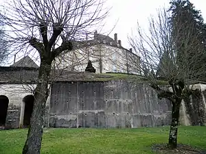
- Kirche Saint-Martin aus dem 19. Jahrhundert
- Schloss Grammont, 1771 errichtet, seit 1964 Monument historique
- Kreuz von Lugny, seit 1950 Monument historique
- Brücke über den Arconce
- Mühle
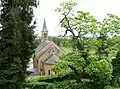 Kirche Saint-Martin
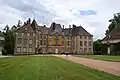 Schloss Grammont
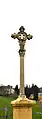 Kreuz von Lugny
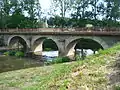 Brücke über den Arconce
Gemeindepartnerschaften
Mit der schweizerischen Gemeinde Mex (Kanton Waadt) besteht eine Partnerschaft.
This article is issued from Wikipedia. The text is licensed under Creative Commons - Attribution - Sharealike. The authors of the article are listed here. Additional terms may apply for the media files, click on images to show image meta data.