Curdin
Curdin ist eine französische Gemeinde mit 319 Einwohnern (Stand: 1. Januar 2019) im Département Saône-et-Loire in der Region Bourgogne-Franche-Comté. Sie gehört zum Arrondissement Charolles und zum Kanton Gueugnon. Die Einwohner werden Curdinois genannt.
| Curdin | ||
|---|---|---|
| ||
| Staat | Frankreich | |
| Region | Bourgogne-Franche-Comté | |
| Département (Nr.) | Saône-et-Loire (71) | |
| Arrondissement | Charolles | |
| Kanton | Gueugnon | |
| Gemeindeverband | Entre Arroux, Loire et Somme | |
| Koordinaten | 46° 36′ N, 4° 0′ O | |
| Höhe | 258–352 m | |
| Fläche | 7,95 km² | |
| Einwohner | 319 (1. Januar 2019) | |
| Bevölkerungsdichte | 40 Einw./km² | |
| Postleitzahl | 71130 | |
| INSEE-Code | 71161 | |

Geographie
Curdin liegt etwa 60 Kilometer ostnordöstlich von Moulins. Nachbargemeinden von Curdin sind La Chapelle-au-Mans im Norden, Gueugnon im Osten, Rigny-sur-Arroux im Süden sowie Neuvy-Grandchamp im Westen.
Bevölkerungsentwicklung
| Jahr | 1962 | 1968 | 1975 | 1982 | 1990 | 1999 | 2006 | 2011 | 2016 |
| Einwohner | 211 | 261 | 216 | 268 | 305 | 319 | 318 | 322 | 317 |
| Quelle: Cassini und INSEE | |||||||||
Sehenswürdigkeiten
- Kirche Saint-Pierre
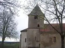
Kirche Saint-Pierre
This article is issued from Wikipedia. The text is licensed under Creative Commons - Attribution - Sharealike. The authors of the article are listed here. Additional terms may apply for the media files, click on images to show image meta data.