Melay (Saône-et-Loire)
Melay ist eine französische Gemeinde mit 968 Einwohnern (Stand 1. Januar 2019) im Département Saône-et-Loire in der Region Bourgogne-Franche-Comté (vor 2016 Bourgogne). Sie gehört zum Arrondissement Charolles und zum Kanton Paray-le-Monial (bis 2015 Marcigny). Die Einwohner werden Melayots genannt.
| Melay | ||
|---|---|---|
| ||
| Staat | Frankreich | |
| Region | Bourgogne-Franche-Comté | |
| Département (Nr.) | Saône-et-Loire (71) | |
| Arrondissement | Charolles | |
| Kanton | Paray-le-Monial | |
| Gemeindeverband | Communauté de communes de Marcigny | |
| Koordinaten | 46° 13′ N, 4° 1′ O | |
| Höhe | 245–353 m | |
| Fläche | 36,44 km² | |
| Einwohner | 968 (1. Januar 2019) | |
| Bevölkerungsdichte | 27 Einw./km² | |
| Postleitzahl | 71340 | |
| INSEE-Code | 71291 | |
| Website | https://www.mairie-melay.fr/ | |
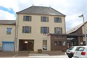 Rathaus (Mairie) von Melay | ||

Geographie
Melay liegt in der Landschaft Charolais. Die Loire begrenzt die Gemeinde im Osten. Nachbargemeinden von Melay sind Artaix im Norden, Saint-Martin-du-Lac im Nordosten, Iguerande im Osten, Paray-le-Monial im Osten, Briennon im Südosten, La Bénisson-Dieu und Noailly im Süden, Vivans im Westen sowie Chenay-le-Châtel im Nordwesten.
Bevölkerungsentwicklung
| Jahr | 1962 | 1968 | 1975 | 1982 | 1990 | 1999 | 2006 | 2011 | 2016 |
| Einwohner | 1.053 | 1.015 | 900 | 876 | 819 | 820 | 830 | 948 | 982 |
| Quelle: Cassini und INSEE | |||||||||
Sehenswürdigkeiten
- Kirche Saint-Étienne
- Turmhügelburg von Bagneux
- Schloss Maulévrier, seit 1991 Monument historique
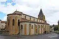 Kirche Saint-Étienne
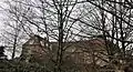 Schloss Maulévrier
Persönlichkeiten
- François Savary de Brèves (1560–1628), Diplomat
This article is issued from Wikipedia. The text is licensed under Creative Commons - Attribution - Sharealike. The authors of the article are listed here. Additional terms may apply for the media files, click on images to show image meta data.