Ballore
Ballore ist eine französische Gemeinde mit 95 Einwohnern (Stand: 1. Januar 2019) im Département Saône-et-Loire in der Region Bourgogne-Franche-Comté. Sie gehört zum Arrondissement Charolles, zum Kanton Charolles (bis 2015: Kanton La Guiche) und zum Kommunalverband Communauté de communes du Charolais.
| Ballore | ||
|---|---|---|
| ||
| Staat | Frankreich | |
| Region | Bourgogne-Franche-Comté | |
| Département (Nr.) | Saône-et-Loire (71) | |
| Arrondissement | Charolles | |
| Kanton | Charolles | |
| Gemeindeverband | Grand Charolais | |
| Koordinaten | 46° 32′ N, 4° 22′ O | |
| Höhe | 312–391 m | |
| Fläche | 10,91 km² | |
| Einwohner | 95 (1. Januar 2019) | |
| Bevölkerungsdichte | 9 Einw./km² | |
| Postleitzahl | 71220 | |
| INSEE-Code | 71017 | |

Geografie
Ballore liegt etwa 46 Kilometer westsüdwestlich von Chalon-sur-Saône am Arconce. Umgeben wird Ballore von den Nachbargemeinden Le Rousset-Marizy im Norden und Nordosten, La Guiche im Osten, Mornay im Süden sowie Martigny-le-Comte im Westen.
Bevölkerungsentwicklung
| Jahr | 1962 | 1968 | 1975 | 1982 | 1990 | 1999 | 2006 | 2013 |
| Einwohner | 159 | 142 | 127 | 115 | 93 | 84 | 82 | 85 |
| Quelle: Cassini und INSEE | ||||||||
Sehenswürdigkeiten
- Archäologische Fundstätte aus dem 3. nachchristlichen Jahrhundert, seit 1943 Monument historique
- Kirche Saint-Denis
- Schloss Ballore
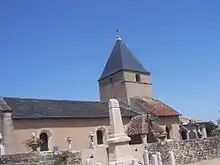
Kirche Saint-Denis
This article is issued from Wikipedia. The text is licensed under Creative Commons - Attribution - Sharealike. The authors of the article are listed here. Additional terms may apply for the media files, click on images to show image meta data.