Saint-Aubin-en-Charollais
Saint-Aubin-en-Charollais ist eine französische Gemeinde mit 467 Einwohnern (Stand: 1. Januar 2019) im Département Saône-et-Loire in der Region Bourgogne-Franche-Comté (vor 2016 Bourgogne). Sie gehört zum Arrondissement Charolles und zum Kanton Charolles (bis 2015: Kanton Palinges).
| Saint-Aubin-en-Charollais | ||
|---|---|---|
| ||
| Staat | Frankreich | |
| Region | Bourgogne-Franche-Comté | |
| Département (Nr.) | Saône-et-Loire (71) | |
| Arrondissement | Charolles | |
| Kanton | Charolles | |
| Gemeindeverband | Grand Charolais | |
| Koordinaten | 46° 30′ N, 4° 13′ O | |
| Höhe | 248–312 m | |
| Fläche | 19,75 km² | |
| Einwohner | 467 (1. Januar 2019) | |
| Bevölkerungsdichte | 24 Einw./km² | |
| Postleitzahl | 71430 | |
| INSEE-Code | 71388 | |

Geographie
Saint-Aubin-en-Charollais liegt etwa 60 Kilometer südöstlich von Chalon-sur-Saône. Nachbargemeinden von Saint-Aubin-en-Charollais sind Palinges im Norden, Saint-Bonnet-de-Vieille-Vigne im Nordosten, Grandvaux im Osten, Baron im Osten und Südosten, Champlecy im Süden, Volesvres im Westen und Südwesten sowie Saint-Vincent-Bragny im Nordwesten.
Durch die Gemeinde führt die Route nationale 79.
Bevölkerungsentwicklung
| Jahr | 1962 | 1968 | 1975 | 1982 | 1990 | 1999 | 2006 | 2013 |
| Einwohner | 508 | 491 | 430 | 350 | 349 | 384 | 421 | 489 |
| Quelle: Cassini und INSEE | ||||||||
Sehenswürdigkeiten
- Kirche Saint-Aubin
- Schloss Moulin-Chipot
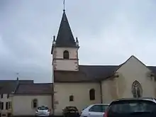
Kirche Saint-Aubin
This article is issued from Wikipedia. The text is licensed under Creative Commons - Attribution - Sharealike. The authors of the article are listed here. Additional terms may apply for the media files, click on images to show image meta data.