Saint-Aubin-des-Coudrais
Saint-Aubin-des-Coudrais ist eine französische Gemeinde mit 912 Einwohnern (Stand 1. Januar 2019) im Arrondissement Mamers im Département Sarthe in der Region Pays de la Loire. Saint-Aubin-des-Coudrais gehört zum Kanton La Ferté-Bernard und zum Gemeindeverband Communauté de communes du Pays de l’Huisne Sarthoise. Die Einwohner werden Saint-Aubinois genannt.
| Saint-Aubin-des-Coudrais | ||
|---|---|---|
| ||
| Staat | Frankreich | |
| Region | Pays de la Loire | |
| Département (Nr.) | Sarthe (72) | |
| Arrondissement | Mamers | |
| Kanton | La Ferté-Bernard | |
| Gemeindeverband | Pays de l’Huisne Sarthoise | |
| Koordinaten | 48° 10′ N, 0° 35′ O | |
| Höhe | 81–166 m | |
| Fläche | 17,40 km² | |
| Einwohner | 912 (1. Januar 2019) | |
| Bevölkerungsdichte | 52 Einw./km² | |
| Postleitzahl | 72400 | |
| INSEE-Code | 72267 | |
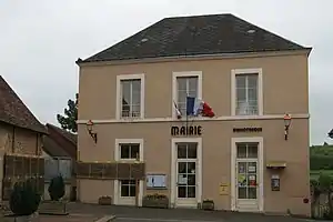 Rathaus (Mairie) von Saint-Aubin-des-Coudrais | ||

Geographie
Saint-Aubin-des-Coudrais liegt etwa dreißig Kilometer nordöstlich von Le Mans. Umgeben wird Saint-Aubin-des-Coudrais von den Nachbargemeinden Dehault im Norden und Nordosten, La Ferté-Bernard im Osten, Saint-Martin-des-Monts im Süden und Südosten, La Bosse im Süden und Westen sowie Saint-Georges-du-Rosay im Nordwesten.
Bevölkerungsentwicklung
| 1962 | 1968 | 1975 | 1982 | 1990 | 1999 | 2006 | 2013 |
|---|---|---|---|---|---|---|---|
| 725 | 655 | 620 | 716 | 757 | 883 | 953 | 936 |
| Quelle: Cassini und INSEE | |||||||
Sehenswürdigkeiten
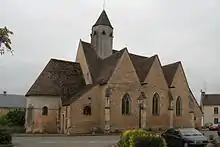
Kirche Saint-Aubin
- Kirche Saint-Aubin aus dem 12. Jahrhundert mit Umbauten aus dem 16. Jahrhundert, seit 1976 Monument historique
Literatur
- Le Patrimoine des Communes de la Sarthe. Flohic Editions, Band 1, Paris 2000, ISBN 2-84234-106-6, S. 500–502.
This article is issued from Wikipedia. The text is licensed under Creative Commons - Attribution - Sharealike. The authors of the article are listed here. Additional terms may apply for the media files, click on images to show image meta data.