Jauzé
Jauzé ist eine französische Gemeinde mit 82 Einwohnern (Stand: 1. Januar 2019) im Département Sarthe in der Region Pays de la Loire. Die Gemeinde liegt im Arrondissement Mamers und im Kanton Bonnétable. Ihre Einwohner heißen Jauzéens.
| Jauzé | ||
|---|---|---|
| ||
| Staat | Frankreich | |
| Region | Pays de la Loire | |
| Département (Nr.) | Sarthe (72) | |
| Arrondissement | Mamers | |
| Kanton | Bonnétable | |
| Gemeindeverband | Maine Saosnois | |
| Koordinaten | 48° 13′ N, 0° 23′ O | |
| Höhe | 66–98 m | |
| Fläche | 5,73 km² | |
| Einwohner | 82 (1. Januar 2019) | |
| Bevölkerungsdichte | 14 Einw./km² | |
| Postleitzahl | 72110 | |
| INSEE-Code | 72148 | |
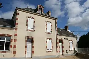 Rathaus (Mairie) von Jauzé | ||

Geografie
Jauzé liegt etwa 26 Kilometer nordnordöstlich von Le Mans und etwa 35 Kilometer südöstlich von Alençon. Umgeben wird Jauzé von den Nachbargemeinden Courcival im Norden, Terrehault im Osten, Briosne-lès-Sables im Süden und Südosten sowie Saint-Aignan im Westen.
Einwohnerentwicklung
| 1962 | 1968 | 1975 | 1982 | 1990 | 1999 | 2006 | 2013 |
|---|---|---|---|---|---|---|---|
| 137 | 134 | 100 | 81 | 75 | 82 | 93 | 88 |
| Quelle: Cassini und INSEE | |||||||
Sehenswürdigkeiten
- Kirche Saint-Barthélemy
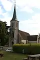 Kirche St. Bartholomäus
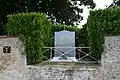 Kriegerdenkmal
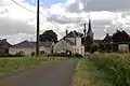 Ortsansicht
Literatur
- Le Patrimoine des Communes de la Sarthe. Flohic Editions, Band 1, Paris 2000, ISBN 2-84234-106-6, S. 242–246.
This article is issued from Wikipedia. The text is licensed under Creative Commons - Attribution - Sharealike. The authors of the article are listed here. Additional terms may apply for the media files, click on images to show image meta data.