La Chapelle-Saint-Fray
La Chapelle-Saint-Fray ist eine französische Gemeinde mit 426 Einwohnern (Stand: 1. Januar 2019) im Département Sarthe in der Region Pays de la Loire. Sie gehört zum Arrondissement Mamers und zum Kanton Loué (bis 2015: Kanton Conlie). Die Einwohner werden Capellofrayens genannt.
| La Chapelle-Saint-Fray | ||
|---|---|---|
| ||
| Staat | Frankreich | |
| Region | Pays de la Loire | |
| Département (Nr.) | Sarthe (72) | |
| Arrondissement | Mamers | |
| Kanton | Loué | |
| Gemeindeverband | Champagne Conlinoise et Pays de Sillé | |
| Koordinaten | 48° 7′ N, 0° 5′ O | |
| Höhe | 71–173 m | |
| Fläche | 6,36 km² | |
| Einwohner | 426 (1. Januar 2019) | |
| Bevölkerungsdichte | 67 Einw./km² | |
| Postleitzahl | 72240 | |
| INSEE-Code | 72066 | |

Geographie
La Chapelle-Saint-Fray liegt etwa 14 Kilometer nordnordwestlich von Le Mans. Umgeben wird La Chapelle-Saint-Fray von den Nachbargemeinden Sainte-Sabine-sur-Longève im Norden, La Bazoge im Osten, La Milesse im Süden und Südosten sowie Domfront-en-Champagne im Westen und Südwesten.
Bevölkerungsentwicklung
| Jahr | 1962 | 1968 | 1975 | 1982 | 1990 | 1999 | 2006 | 2013 |
| Einwohner | 268 | 238 | 174 | 241 | 330 | 364 | 384 | 469 |
| Quelle: Cassini und INSEE | ||||||||
Sehenswürdigkeiten
- Kirche Saint-Fray
- Kapelle von Poché
- Mühle von L'Essart
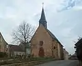 Kirche Saint-Fray
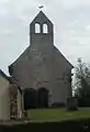 Kapelle von Poché
Literatur
- Le Patrimoine des Communes de la Sarthe. Flohic Editions, Band 1, Paris 2000, ISBN 2-84234-106-6, S. 403–405.
This article is issued from Wikipedia. The text is licensed under Creative Commons - Attribution - Sharealike. The authors of the article are listed here. Additional terms may apply for the media files, click on images to show image meta data.