Montaillé
Montaillé ist eine französische Gemeinde mit 521 Einwohnern (Stand 1. Januar 2019) im Département Sarthe in der Region Pays de la Loire. Sie gehört zum Arrondissement Mamers und zum Kanton Saint-Calais. Die Einwohner werden Aillémontains genannt.
| Montaillé | ||
|---|---|---|
| ||
| Staat | Frankreich | |
| Region | Pays de la Loire | |
| Département (Nr.) | Sarthe (72) | |
| Arrondissement | Mamers | |
| Kanton | Saint-Calais | |
| Gemeindeverband | Vallées de la Braye et de l’Anille | |
| Koordinaten | 47° 56′ N, 0° 42′ O | |
| Höhe | 102–182 m | |
| Fläche | 30,55 km² | |
| Einwohner | 521 (1. Januar 2019) | |
| Bevölkerungsdichte | 17 Einw./km² | |
| Postleitzahl | 72120 | |
| INSEE-Code | 72204 | |

Geographie
Montaillé liegt etwa 40 Kilometer ostsüdöstlich von Le Mans. Nachbargemeinden von Montaillé sind Semur-en-Vallon im Norden, Conflans-sur-Anille im Osten, Saint-Calais im Süden und Südosten, Sainte-Cérotte im Süden und Südwesten, Écorpain im Westen sowie Coudrecieux im Westen und Nordwesten.
Bevölkerungsentwicklung
| Jahr | 1962 | 1968 | 1975 | 1982 | 1990 | 1999 | 2006 | 2013 |
| Einwohner | 721 | 668 | 556 | 502 | 542 | 515 | 541 | 579 |
| Quelle: Cassini und INSEE | ||||||||
Sehenswürdigkeiten
- Kirche Saint-Jean-Baptiste
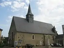
Kirche Saint-Jean-Baptiste
This article is issued from Wikipedia. The text is licensed under Creative Commons - Attribution - Sharealike. The authors of the article are listed here. Additional terms may apply for the media files, click on images to show image meta data.