Courcemont
| Courcemont | ||
|---|---|---|
.svg.png.webp)
|
| |
| Staat | Frankreich | |
| Region | Pays de la Loire | |
| Département (Nr.) | Sarthe (72) | |
| Arrondissement | Mamers | |
| Kanton | Bonnétable | |
| Gemeindeverband | Maine Saosnois | |
| Koordinaten | 48° 10′ N, 0° 21′ O | |
| Höhe | 63–143 m | |
| Fläche | 19,33 km² | |
| Einwohner | 676 (1. Januar 2019) | |
| Bevölkerungsdichte | 35 Einw./km² | |
| Postleitzahl | 72110 | |
| INSEE-Code | 72101 | |
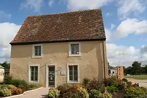 Rathaus (Mairie) von Courcemont | ||

Courcemont ist eine französische Gemeinde mit 676 Einwohnern (Stand: 1. Januar 2019) im Département Sarthe in der Region Pays de la Loire. Sie gehört zum Arrondissement Le Mans und zum Kanton Bonnétable (bis 2015: Kanton Ballon). Die Einwohner werden Courcemontais genannt.
Geographie
Courcemont liegt etwa 22 Kilometer nordöstlich von Le Mans. Umgeben wird Courcemont von den Nachbargemeinden Saint-Aignan im Norden, Briosne-lès-Sables im Osten, Beaufay im Süden, Saint-Mars-sous-Ballon im Westen sowie Mézières-sur-Ponthouin im Nordwesten. Das Gemeindegebiet wird vom Flüsschen Morte Parence und einigen seiner Zuflüsse durchquert.
Bevölkerungsentwicklung
| Jahr | 1962 | 1968 | 1975 | 1982 | 1990 | 1999 | 2006 | 2012 |
| Einwohner | 835 | 825 | 702 | 612 | 556 | 574 | 643 | 681 |
| Quelle: Cassini und INSEE | ||||||||
Sehenswürdigkeiten
- Kirche Saint-Barthélemy aus dem 11. Jahrhundert mit Umbauten aus dem 12. und 14. Jahrhundert
- Schloss Le Chesnay
- Waschhaus

Kirche Saint-Barthélemy
Literatur
- Le Patrimoine des Communes de la Sarthe. Flohic Editions, Band 1, Paris 2000, ISBN 2-84234-106-6, S. 89–93.
This article is issued from Wikipedia. The text is licensed under Creative Commons - Attribution - Sharealike. The authors of the article are listed here. Additional terms may apply for the media files, click on images to show image meta data.