Bouër
Bouër ist eine französische Stadt mit 344 Einwohnern (Stand: 1. Januar 2019) im Arrondissement Mamers im Département Sarthe in der Region Pays de la Loire. Bouër gehört zum Kanton La Ferté-Bernard (bis 2015: Kanton Tuffé) und zum Gemeindeverband Communauté de communes du Pays de l’Huisne Sarthoise. Die Einwohner werden Bouëriens genannt.
| Bouër | ||
|---|---|---|
| ||
| Staat | Frankreich | |
| Region | Pays de la Loire | |
| Département (Nr.) | Sarthe (72) | |
| Arrondissement | Mamers | |
| Kanton | La Ferté-Bernard | |
| Gemeindeverband | Pays de l’Huisne Sarthoise | |
| Koordinaten | 48° 5′ N, 0° 38′ O | |
| Höhe | 85–192 m | |
| Fläche | 12,00 km² | |
| Einwohner | 344 (1. Januar 2019) | |
| Bevölkerungsdichte | 29 Einw./km² | |
| Postleitzahl | 72390 | |
| INSEE-Code | 72041 | |

Geographie
Bouër liegt etwa 33 Kilometer ostnordöstlich von Le Mans. Umgeben wird Bouër von den Nachbargemeinden Saint-Maixent im Norden und Nordosten, Lavaré im Süden und Osten sowie Le Luart im Westen.
Bevölkerungsentwicklung
| 1962 | 1968 | 1975 | 1982 | 1990 | 1999 | 2006 | 2013 |
|---|---|---|---|---|---|---|---|
| 250 | 239 | 204 | 177 | 185 | 179 | 238 | 330 |
| Quelle: Cassini und INSEE | |||||||
Sehenswürdigkeiten
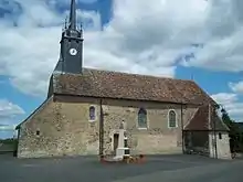
Kirche Saint-Pierre
- Kirche Saint-Pierre, seit 1927 Monument historique
- Schloss und Domäne Courgeon
This article is issued from Wikipedia. The text is licensed under Creative Commons - Attribution - Sharealike. The authors of the article are listed here. Additional terms may apply for the media files, click on images to show image meta data.