Gungwiller
| Gungwiller | ||
|---|---|---|

|
| |
| Staat | Frankreich | |
| Region | Grand Est | |
| Département (Nr.) | Bas-Rhin (67) | |
| Arrondissement | Saverne | |
| Kanton | Ingwiller | |
| Gemeindeverband | Alsace Bossue | |
| Koordinaten | 48° 53′ N, 7° 9′ O | |
| Höhe | 303–358 m | |
| Fläche | 1,69 km² | |
| Einwohner | 277 (1. Januar 2019) | |
| Bevölkerungsdichte | 164 Einw./km² | |
| Postleitzahl | 67320 | |
| INSEE-Code | 67178 | |
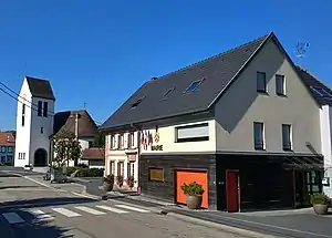
 Protestantische Kirche und Rathaus | ||
Gungwiller (dt. Gungweiler) ist eine französische Gemeinde mit 277 Einwohnern (Stand 1. Januar 2019) im Département Bas-Rhin in der Region Grand Est (bis 2015 Elsass).
Geografie
Die Gemeinde liegt im Krummen Elsass zwischen Phalsbourg und Sarre-Union,
Geschichte
Von 1871 bis zum Ende des Ersten Weltkrieges gehörte Gungwiller als Teil des Reichslandes Elsaß-Lothringen zum Deutschen Reich und war dem Kreis Zabern im Bezirk Unterelsaß zugeordnet.
Bevölkerungsentwicklung
| Jahr | 1910 | 1962 | 1968 | 1975 | 1982 | 1990 | 1999 | 2007 | 2017 |
| Einwohner | 313[1] | 241 | 265 | 310 | 263 | 219 | 233 | 297 | 279 |
Literatur
- Le Patrimoine des Communes du Bas-Rhin. Flohic Editions, Band 1, Charenton-le-Pont 1999, ISBN 2-84234-055-8, S. 328.
Weblinks
Commons: Gungwiller – Sammlung von Bildern, Videos und Audiodateien
- Gungwiller bei der Communauté de communes d'Alsace Bossue (französisch)
Einzelnachweise
This article is issued from Wikipedia. The text is licensed under Creative Commons - Attribution - Sharealike. The authors of the article are listed here. Additional terms may apply for the media files, click on images to show image meta data.
