Willgottheim
| Willgottheim | ||
|---|---|---|
|
| |
| Staat | Frankreich | |
| Region | Grand Est | |
| Département (Nr.) | Bas-Rhin (67) | |
| Arrondissement | Saverne | |
| Kanton | Bouxwiller | |
| Gemeindeverband | Kochersberg | |
| Koordinaten | 48° 40′ N, 7° 31′ O | |
| Höhe | 181–333 m | |
| Fläche | 9,22 km² | |
| Einwohner | 1.088 (1. Januar 2019) | |
| Bevölkerungsdichte | 118 Einw./km² | |
| Postleitzahl | 67370 | |
| INSEE-Code | 67532 | |
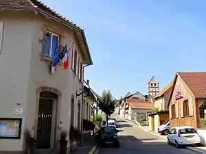 Mairie Willgottheim | ||

Willgottheim ist eine französische Gemeinde mit 1088 Einwohnern (Stand 1. Januar 2019) im Département Bas-Rhin in der Region Grand Est (bis 2015 Elsass). Willgottheim liegt im Kochersberg zwischen Landersheim und Neugartheim-Ittlenheim. Am 1. Mai 1972 fusionierte Willgottheim mit der Gemeinde Wœllenheim.
Bevölkerungsentwicklung
| Jahr | 1962 | 1968 | 1975 | 1982 | 1990 | 1999 | 2007 | 2017 |
| Einwohner | 619 | 622 | 597 | 633 | 602 | 914 | 1090 | 1085 |
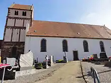 Kirche St. Mauritius |
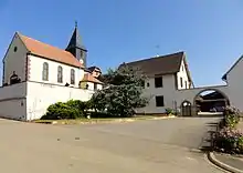 Kirche St. Andreas im Ortsteil Woellenheim |
Literatur
- Le Patrimoine des Communes du Bas-Rhin. Flohic Editions, Band 2, Charenton-le-Pont 1999, ISBN 2-84234-055-8, S. 1475–1479.
Weblinks
Commons: Willgottheim – Sammlung von Bildern, Videos und Audiodateien
This article is issued from Wikipedia. The text is licensed under Creative Commons - Attribution - Sharealike. The authors of the article are listed here. Additional terms may apply for the media files, click on images to show image meta data.