Bazeilles-sur-Othain
| Bazeilles-sur-Othain | ||
|---|---|---|

|
| |
| Staat | Frankreich | |
| Region | Grand Est | |
| Département (Nr.) | Meuse (55) | |
| Arrondissement | Verdun | |
| Kanton | Montmédy | |
| Gemeindeverband | Pays de Montmédy | |
| Koordinaten | 49° 30′ N, 5° 26′ O | |
| Höhe | 187–337 m | |
| Fläche | 7,71 km² | |
| Einwohner | 115 (1. Januar 2019) | |
| Bevölkerungsdichte | 15 Einw./km² | |
| Postleitzahl | 55600 | |
| INSEE-Code | 55034 | |
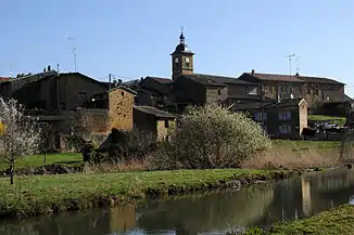 Ortsmitte | ||

Bazeilles-sur-Othain ist eine französische Gemeinde mit 115 Einwohnern (Stand: 1. Januar 2019) im Département Meuse in der Region Grand Est (bis 2015 Lothringen). Sie gehört zum Arrondissement Verdun und ist Teil des Kantons Montmédy.
Geografie
Bazeilles-sur-Othain liegt im Norden der Region Grand-Est am Fluss Othain an der Grenze zu Belgien.
Bevölkerungsentwicklung
| Jahr | 1962 | 1968 | 1975 | 1982 | 1990 | 1999 | 2006 | 2015 |
| Einwohner | 118 | 118 | 109 | 96 | 72 | 91 | 97 | 118 |
| Quelle: Cassini und INSEE | ||||||||
Sehenswürdigkeiten
- Kirche Saint-Martin von 1755
- Waschhaus aus dem 19. Jahrhundert

Kirche Saint-Martin
Literatur
- Le Patrimoine des Communes de la Meuse. Flohic Editions, Band 2, Paris 1999, ISBN 2-84234-074-4, S. 666–668.
This article is issued from Wikipedia. The text is licensed under Creative Commons - Attribution - Sharealike. The authors of the article are listed here. Additional terms may apply for the media files, click on images to show image meta data.