Villemotier
Villemotier ist eine französische Gemeinde im Département Ain in der Region Auvergne-Rhône-Alpes. Sie gehört zum Kanton Saint-Étienne-du-Bois im Arrondissement Bourg-en-Bresse.
| Villemotier | ||
|---|---|---|
| ||
| Staat | Frankreich | |
| Region | Auvergne-Rhône-Alpes | |
| Département (Nr.) | Ain (01) | |
| Arrondissement | Bourg-en-Bresse | |
| Kanton | Saint-Étienne-du-Bois | |
| Gemeindeverband | Bassin de Bourg-en-Bresse | |
| Koordinaten | 46° 21′ N, 5° 19′ O | |
| Höhe | 197–261 m | |
| Fläche | 13,88 km² | |
| Einwohner | 615 (1. Januar 2019) | |
| Bevölkerungsdichte | 44 Einw./km² | |
| Postleitzahl | 01270 | |
| INSEE-Code | 01445 | |
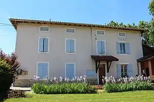 Mairie Villemotier | ||

Geografie und Infrastruktur
Die Gemeinde grenzt im Nordwesten an Pirajoux, im Norden an Coligny, im Nordosten an Salavre, im Osten an Verjon, im Südosten an Courmangoux, im Süden an Saint-Étienne-du-Bois, im Südwesten an Bény und im Westen an Marboz.
Die Route nationale 83 tangiert Villemotier im Nordwesten.
Bevölkerungsentwicklung
| Jahr | 1962 | 1968 | 1975 | 1982 | 1990 | 1999 | 2008 | 2014 |
|---|---|---|---|---|---|---|---|---|
| Einwohner | 434 | 403 | 372 | 384 | 419 | 455 | 597 | 664 |
| Quellen: Cassini und INSEE | ||||||||
Sehenswürdigkeiten
- Mühle (Moulin de Pertuizet), Monument historique
- Kirche Saint-Léger
- Kriegerdenkmal
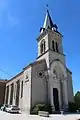 Kirche Saint-Léger
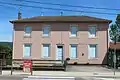 Schulhaus
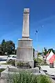 Kriegerdenkmal
Weblinks
Commons: Villemotier – Sammlung von Bildern, Videos und Audiodateien
This article is issued from Wikipedia. The text is licensed under Creative Commons - Attribution - Sharealike. The authors of the article are listed here. Additional terms may apply for the media files, click on images to show image meta data.