Sainte-Marie-de-Vatimesnil
Sainte-Marie-de-Vatimesnil ist eine französische Gemeinde mit 280 Einwohnern (Stand: 1. Januar 2019) im Département Eure in der Region Normandie (vor 2016 Haute-Normandie). Sie gehört zum Arrondissement Les Andelys und zum Kanton Gisors (bis 2015: Kanton Étrépagny).
| Sainte-Marie-de-Vatimesnil | ||
|---|---|---|
| ||
| Staat | Frankreich | |
| Region | Normandie | |
| Département (Nr.) | Eure (27) | |
| Arrondissement | Les Andelys | |
| Kanton | Gisors | |
| Gemeindeverband | Vexin Normand | |
| Koordinaten | 49° 17′ N, 1° 35′ O | |
| Höhe | 83–144 m | |
| Fläche | 7,47 km² | |
| Einwohner | 280 (1. Januar 2019) | |
| Bevölkerungsdichte | 37 Einw./km² | |
| Postleitzahl | 27150 | |
| INSEE-Code | 27567 | |
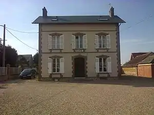 Rathaus (Mairie) von Sainte-Marie-de-Vatimesnil | ||

Geographie
Sainte-Marie-de-Vatimesnil liegt etwa 60 Kilometer ostsüdöstlich von Rouen. Umgeben wird Sainte-Marie-de-Vatimesnil von den Nachbargemeinden Hacqueville im Norden und Westen, Étrépagny im Norden, Chauvincourt-Provemont im Nordosten, Gamaches-en-Vexin im Osten und Nordosten, Villers-en-Vexin im Süden und Südosten, Mouflaines im Süden sowie Richeville im Südwesten.
Geschichte
1844 wurden Sainte-Marie-des-Champs und Vatimesnil zur heutigen Gemeinde vereinigt.
Bevölkerungsentwicklung
| Jahr | 1962 | 1968 | 1975 | 1982 | 1990 | 1999 | 2006 | 2013 |
| Einwohner | 223 | 211 | 176 | 194 | 204 | 235 | 245 | 253 |
| Quelle: Cassini und INSEE | ||||||||
Sehenswürdigkeiten
- Kirche Sainte-Marie-des-Champs
- Kirche Saint-Michel in Vatimesnil
- Schloss aus dem 19. Jahrhundert
- Kapelle des Schlosses von Saint-Michel-Archange aus dem 19. Jahrhundert
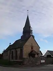
Kirche Sainte-Marie-des-Champs
This article is issued from Wikipedia. The text is licensed under Creative Commons - Attribution - Sharealike. The authors of the article are listed here. Additional terms may apply for the media files, click on images to show image meta data.